Water in motion is one of those timeless processes in nature that hold our gaze and set our thoughts free. For landlocked Iowans, far removed from the rhythmic sight and sound of ocean surf, the strong silent flow of a large river has its own soothing and enduring attraction.
Iowa also has hundreds of small brooks and creeks that can be crossed with a good long-jump or by convenient stepping-stones. It is time well spent to look closely at these large and small drainageways, for they demonstrate the most significant geological process presently at work on the Iowa landscape—the action of water. Rivers construct distinctive, flat-floored corridors known as alluvial plains that are underlain by water-transported deposits. These topographic corridors weave throughout the state’s other landform regions, but together they constitute the last of Iowa’s seven physiographic regions, the Alluvial Plains.
During the tens to hundreds of thousands of years since the various Pleistocene glaciers melted from Iowa, rivers have carved the state’s valleys and partially filled them with layered deposits of gravel, sand, silt, and clay. The streams draining Iowa’s land surface today range in size from small rills on upland slopes to the broad Missouri and Mississippi lowlands along the state’s western and eastern borders. Only these largest segments of the Alluvial Plains region stand out at the scale of the map. These drainage networks transfer water and sediment from the highest portions of the watershed downslope through increasingly larger streams and rivers and eventually to the Mississippi delta in the Gulf of Mexico.
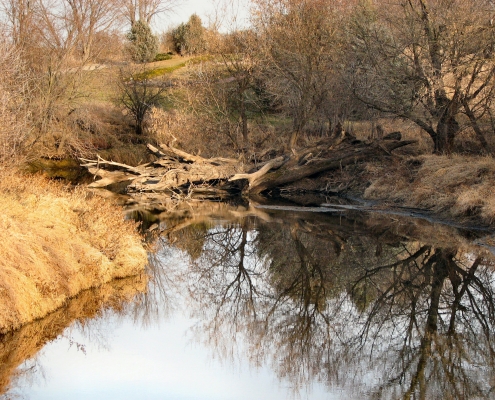
Along shallow stream channels, it is easy to observe individual particles of sediment being swept quickly downstream through narrow chutes. Sediment grains may lodge temporarily in a quiet pool or at the downstream end of a rippled shoal of other grains. It is also common to see the outer bends of meandering stream channels undercut their steep banks, causing material to slump into the flow, while sediment accumulates along the shallower inside curves of bends, forming point-bar deposits. Neither sediment nor water moves at a uniform pace through river systems. More water and stronger currents can carry greater amounts of larger-diameter materials such as pebbles, cobbles, and boulders over longer distances. Lower velocities cause deposition of the coarser load and transport of only finergrained particles of silt and clay. Within river systems, episodes of downcutting and sediment transport alternate with lengthy periods of sediment storage on both small and large scales and over short as well as long periods.
The network of pathways that rivers have carved into Iowa’s land surface is seen on the topographic relief map. Landscape features resulting from the action of rivers appear along the Missouri and Mississippi valleys, as well as along all of the state’s interior streams. Each valley contains a collection of landforms that record portions of the river’s geologic past, including evidence of large-scale horizontal and vertical changes within its valley.
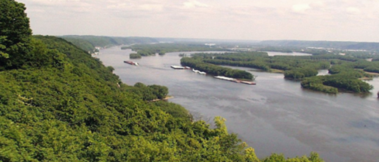
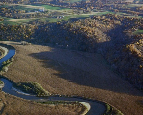
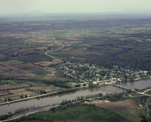
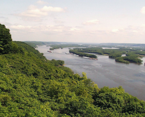
Floodplains, as the name implies, are nearly level though often uneven lowlands adjacent to a river channel. The plains are submerged when a river channel carries excess water, as often occurs in the spring after snowmelt or heavy rains. In river valleys, active erosion and deposition take place on floodplains, and valley floors are often scarred with low ridges and swales marking former positions of a river channel. As a river meanders across its floodplain, channel cutoffs occur, sometimes leaving isolated crescent-shaped bodies of water known as oxbow lakes in the abandoned channel loops. Backwater sloughs and stands of timber frequently indicate these poorly drained meander scars. These various landform features, while present along many Iowa rivers, exist on a grand scale within the Missouri and Mississippi valleys. The curved intermingling of land and water along the lengths of these broad alluvial corridors explains their important role as flyways, hosting hundreds of thousands of migratory waterfowl each spring and fall. The watery lowlands also support other riverbank dwellers, such as beaver and muskrat, as well as a wide variety of wetland plant communities. DeSoto Bend National Wildlife Refuge in Harrison County and Lake Odessa in Louisa County, part of the Mark Twain National Wildlife Refuge, are good examples of ecological habitats supported by alluvial plains.
The geologic restlessness of rivers is also preserved in historical documents. When maps of the Missouri River drawn by the Lewis and Clark expedition in 1804 are compared with later steamboat company and government surveys, they show an animated river, its floodplain etched with intricate scrolls produced by shifting loops of the river’s course. Considerable political and legal strife has occurred because state boundaries and landownership records were based on the position of the Missouri River at a single date in history.
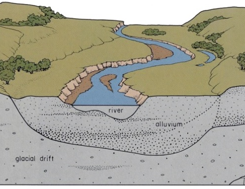
Nor do river channels and floodplains remain vertically stationary within their valleys. Evidence for these large-scale changes is recorded in terraces and benches along valley sides and in the depth of alluvial deposits that backfill a valley’s original trench, buried beneath the present floodplain. Terraces and benches are nearly level surfaces but are elevated above existing floodplains, usually by a distinct slope or scarp. They are remnants of earlier floodplains, abandoned when a river began a new episode of downcutting. Like floodplains, terraces are composed of materials transported by a river-stratified
assortments of clay, silt, sand, and gravel. These generally porous deposits allow easy infiltration and subsurface movement of water. Benches, on the other hand, while looking like terraces and veneered with alluvial deposits, are underlain by a shelf of older material, which is not alluvium but is usually bedrock or glacial drift that resisted the river’s downcutting. Multiple terraces and benches in a valley reflect the complexity of a river’s history, as each lower topographic level represents a more recent step in time as the river eroded its valley more deeply. Fine examples of these features occur along the Des Moines Valley between Fort Dodge and Des Moines, especially the Brushy Creek valley east of Lehigh in southeast Webster County.
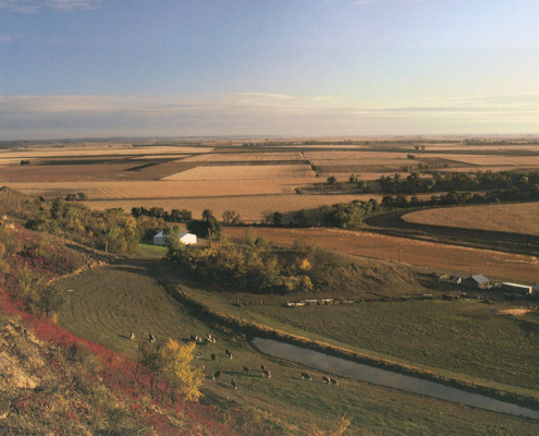
Small tributaries entering a main valley are often steep-gradient, intermittent streams. During episodes of discharge from uplands out onto the more level flood plain, terrace, or bench, these small streams lose their capacity to carry sediment. Fan-shaped aprons of alluvium accumulate at the abrupt change in slope, burying older floodplain materials and soils beneath them. Alluvial fans frequently can be identified along valley margins by the interruptions in field patterns, reflecting subtle changes in slope and drainage.
While most of the landforms and deposits found on alluvial plains reflect the effects of flowing water, we can also see the influence of wind. During seasonal low-flow conditions along stream channels, alluvial deposits emerge as sandbars. If not anchored by vegetation, sand and silt can be blown onto floodplain and terrace surfaces as well as onto higher elevations along valley margins. These accumulations of dune sand appear along terrace edges or fringe the uplands of major valleys where they are often held in place by stands of oaks. Sand-dune topography occurs downwind of broad reaches of valley floor, as along the Mississippi and segments of the Des Moines, Skunk, Iowa, and Cedar rivers in eastern Iowa. Rochester Cemetery in Cedar County, known for its colorful spring wildflowers and stately oaks, and Marietta Sand Prairie, a state preserve in Marshall County, both host native plant species in upland sand-dune habitats. In occasional hollows or depressions (blowouts) among the dunes, ponds form where drainage is sealed by underlying clays; these wetlands are another unusual and limited habitat in Iowa. Behrens Ponds and Woodland State Preserve in Linn County is a good example; Rhexia Pond in Muscatine County is another. A few dune fields are active today, shifting seasonally with the winds, as at Sand Cove on a high terrace of the Upper Iowa River in Allamakee County and at Big Sand Mound, a terrace remnant in the Mississippi Valley straddling the Muscatine-Louisa county line. Most dune tracts in Iowa are presently stabilized; they originated during late Wisconsinan time, and many were reactivated in response to the warmer, drier climates that existed 4,000 to 8,000 years ago during an arid portion of the Holocene called the Hypsithermal, the period of maximum postglacial warming.
The size, shape, and complexity of alluvial plains landforms depend on the individual river’s past experience, including the age of its valley, the long-term variations in available water and sediment, the geologic material into which the valley is carved, and fluctuations in the level of the water body into which the river flows. These factors control valley characteristics and affect landforms along alluvial plains throughout the state.
The youngest valleys in Iowa are found eroded into the low-relief landscapes of the Des Moines Lobe. Compared to others in the state, these valleys have barely begun to excavate a place for themselves in the landscape. As the Des Moines Lobe glacier melted from this area between 14,000 and 11,000 years ago, only a few large valleys developed—the Boone, Raccoon, Ocheyedan, Winnebago, and the upper reaches of the Des Moines, Skunk, Iowa, and Little Sioux. These valleys were excavated by large volumes of meltwater, and their older terraces contain high-energy accumulations of coarse sand and gravel originating from melting ice and left in place by valley downcutting. Many of Iowa’s rivers appear too small to have excavated the valleys in which they flow. These underfit streams and oversized valleys are clear evidence of the enormous volumes of glacial meltwater that once flowed through them.
A well-integrated network of drainageways extends across the more rolling and steeply sloping landscapes of the remaining regions in northwestern, southern, and northeastern Iowa. Valleys in these regions generally are carved into older glacial materials deposited more than 500,000 years ago, and their older terraces often are mantled with late-glacial deposits of loess, indicating an age greater than 12,500 years. Western Iowa streams are particularly noted for their deep gullies carved into thick, easily eroded loess deposits. Valleys in extreme northeastern Iowa are also distinct, with narrow gorges entrenched deeply into bedrock. These valleys, however, were cut in response to the deepening Mississippi Valley, not by glacial meltwater draining through them.
The Missouri and Mississippi alluvial plains are distinct among Iowa’s valleys because of their great size and the fact that they owe their origins to events that occurred outside the state’s boundaries. Both valleys carried large volumes of glacial meltwater in their headwaters between 30,000 and 9,500 years ago; in addition, they were principal sources of the loess mantling much of the Midwest. The Mississippi Valley’s geographic alignment today is a compromise, determined in part by ancestral ice-marginal streams accompanying Pre-Illinoian glacial advances out of the northwest over 500,000 years ago and the Illinoian advance from the northeast about 150,000 years ago. The valley along Iowa’s border was finally knit together by massive meltwater drainage diversions that excavated a new channel from Clinton to Muscatine (the Port Byron Gorge) between 25,000 and 21 ,000 years ago. The geological evolution of the Missouri Valley is less well known, but evidence shows it shared a similar history. Rivers with headwaters in the central Rocky Mountains once flowed eastward across western Iowa, perhaps all the way to the ancestral Mississippi system. These waters were diverted southward by Pre-Illinoian glacial advances into the region, and the Missouri Valley’s final position probably was established by or during Illinoian time.
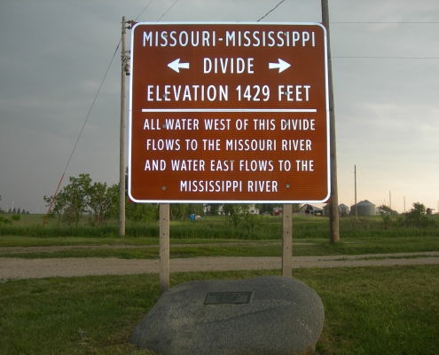
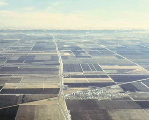
A drainage divide marks the distribution of major rivers in Iowa and separates the watersheds of the Missouri and Mississippi rivers. The Mississippi-Missouri basin is one of the world’s largest drainage systems. Rivers in the western one-third of Iowa drain southwestward to the Missouri, while those in the remainder of the state drain southeastward to the Mississippi. This major divergence of Iowa’s surface-water flow toward opposite ends of the state suggests the presence of some prominent topographic ridge; however, the divide is seldom sufficiently elevated above the surrounding land surface to be distinguished by the eye. Three-fourths of a mile east of Arcadia, along U.S. 30 in Carroll County, is a marker that notes the crossing of this boundary, one of the Midwest’s most significant yet modest geographic thresholds.
North of Cherokee County is an obvious deviation from the divide’s northwesterly trend. The waters along this portion of the Little Sioux basin, including the Ocheyedan River, once flowed southeast to the Mississippi system. This drainage was diverted about 14,000 years ago when the Des Moines Lobe glacier blocked the rivers, forming a large but short-lived ice-marginal lake at Spencer in Clay County. Glacial Lake Spencer eventually overflowed; its waters sought a route around the ice blockage, scouring a new canyon-like valley between Sioux Rapids and Peterson in Buena Vista County and connecting westward with the ancestral Little Sioux River, a tributary of the Missouri. This drainage became permanent, doubling the size of the Little Sioux River basin. Its former orientation, however, is still noticeable in the altered alignment of the state’s major drainage divide.
The matter of ice-marginal lakes is also tied to past interpretations of the Lake Calvin area in Louisa and Muscatine counties. This prominent lowland between the converging Iowa and Cedar rivers was regarded in the early geological literature as the site of a large lake formed when the two rivers were blocked by the westward advance of Illinoian ice into southeast Iowa. Such drainage disruptions undoubtedly occurred; prominent diversion channels of the Mississippi can be seen today as broad swales crossing the eastern Iowa uplands in Clinton County (Goose Lake Channel) and Scott and Muscatine counties (Cleona Channel). Unresolved, however, is the location for a diversion channel south of the Iowa-Cedar drainage. Researchers now suggest the combined drainage may have flowed south beneath the glacial ice. At any rate, stratigraphic studies and radiocarbon dating indicate the landscapes within the Lake Calvin basin, formerly thought to be remnants of Illinoian lake beds, are actually composed of much younger Wisconsinan and Holocene deposits. The floodplains, terraces, dunes, and thick alluvial deposits that characterize this area are the result of complex alluvial origins. If continuous lake deposits existed, they have since been buried, reworked, or removed by erosion.
Alluvial processes, easily observed but seldom appreciated for their geologic significance, have been at work for much of the Earth’s history. For example, ancient river channels now filled with sandstone are part of Iowa’s sedimentary rock records, especially those of Pennsylvanian and Cretaceous age. They are evidence of river courses through ancient landscapes, flowing to oceans of which only fossils and rock remain. Good exposures of these alluvial channel sandstones can be seen at Wildcat Den, Ledges, Dolliver, and Springbrook state parks. Younger valleys carved into Iowa’s bedrock were buried by various Pleistocene glacial deposits and are now hidden from view. Some of these buried valleys contain deposits of alluvial sand and gravel sought by well drillers for groundwater supplies.
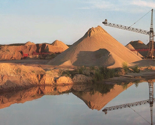
The deposits of sand and gravel associated with alluvial plains statewide are important sources of groundwater. The capacity of alluvial materials to yield water to wells varies along a valley’s length. These variations are caused by changes in the deposits that reflect their past environments of deposition. The source of groundwater in these alluvial aquifers is precipitation and runoff that percolate through soils. Groundwater levels in alluvial deposits change throughout the year, depending on the frequency and intensity of rainfall. A river level usually indicates the position of the local water table or the top of the zone of groundwater saturation, as do many of the oxbow lakes and sloughs on an adjoining floodplain.
The network of alluvial plains established through the Iowa landscape by rivers and their valleys has had a significant impact on patterns of human activity. These natural corridors offered pathways along which travel and settlement took place in both historic and prehistoric times. Archaeological sites are concentrated along bluffs and terraces of large valleys. Effigy Mounds National Monument as well as Fish Farm Mounds, Turkey River Mounds, Malchow Mounds, Little Maquoketa Mounds,and Toolesboro Mounds state preserves are all prehistoric earthworks that overlook or are within the Mississippi Valley.
Episodes of alluvial fan development along the state’s valleys overlapped periods of prehistoric occupation, resulting in the geologic burial of many archaeological sites. Landscape evolution studies of Iowa’s alluvial plains thus are providing important new information to archaeologists and natural-resource planners about possible preservation of other significant but less obvious prehistoric cultural remains in Iowa.
Marquette and Joliet, the first explorers of European descent to make contact with the American West, arrived in the upper Mississippi Valley via the Wisconsin River in 1673 at what is now Pikes Peak State Park in Clayton County. By the time of the American Revolution in 1776, the lead and zinc deposits mined along the Mississippi Valley were an important national resource. Julien Dubuque’s tract, known as the Mines of Spain, marked the beginning of permanent Euro-American settlement in Iowa. Nearly all of Iowa’s principal cities and towns grew from settlements along river valleys. The routes of early exploration became indispensable arteries of supply, travel, and commerce as the state developed.
Though alluvial plains occupy a small percentage of Iowa’s land area, society place increasing demands on them. In addition to urban and industrial use, valleys support intensive agriculture, expanding recreational activities, increased pumping of groundwater for urban, industrial, and irrigation uses, extraction of sand-and-gravel resources, and important wetland habitats—and they continue to perform their geologically designed function of accommodating floodwaters. The hazards to people and property from these recurring geologic events should be a basic consideration of all land-use decisions in valley landscapes. In addition, this intense utilization, combined with a shallow, unprotected groundwater resource, makes alluvial plains especially vulnerable to contamination.
Author: Jean C. Prior
Edited by: Drew Hutchinson
This information is based on the book Landforms of Iowa, by Jean C. Prior, published by the University of Iowa Press, Iowa City, in 1991. The book was designed and illustrated by Patricia J. Lohmann.