Studying Iowa’s nearly 3 billion year rock record has been one of the principle activities at the Iowa Geological Survey since its inception. Stratigraphic research focuses on the correlation by characterizing the lithology, distribution, and thickness of geologic units, as well as establishing the three dimensional relationships between units.
Projects
Stratigraphic Studies
Sponsor: U.S. Geological Survey, others
Background: The first stratigraphic studies in Iowa in the 1800s focused on the identification of natural resources. Studies since have included a wide range of research areas related to rock and mineral resources, hydrologic assessments, and paleontology.
Goals: The ability to define and understand each unit is key to correlating them in a regional and global context. This knowledge allows geologists to provide the information necessary to answer questions related to sustainability, economic development, and water resource investigations.
IGS Strategies: Our products include:
- Maps
- Reports
- Field guides
- Hydrologic models
- Sample collection and analysis
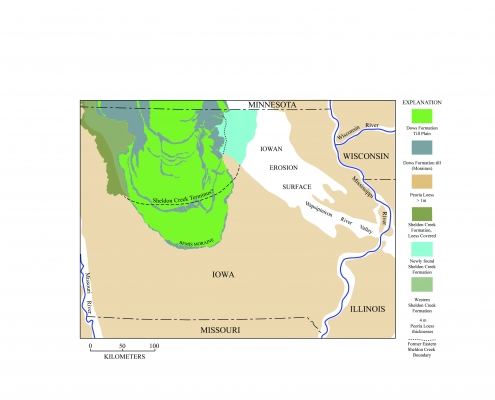
Mid-Wisconsin Sheldon Creek Formation
Sponsor: U.S. Geological Survey
Background: IGS has been studying the timing and distribution of the mid-Wisconsin Sheldon Creek Formation in Iowa for nearly 10 years. Researchers have long recognized that a pre-Des Moines Lobe glacial advance was present in Iowa, and initially referred to this as the Tazewell till. Later work in the 1990s renamed this advance the Sheldon Creek Formation; however, the distribution and timing were still in question.
Recent data suggests that two advances of the Sheldon Creek were present in Iowa, one between 46,000-40,000 years ago and another from 34,000 to 29,000 years ago.
Goals: Better understand, document, and map this formation.
IGS Strategies: Conduct a detailed analysis of the lithologic characteristics of these units.
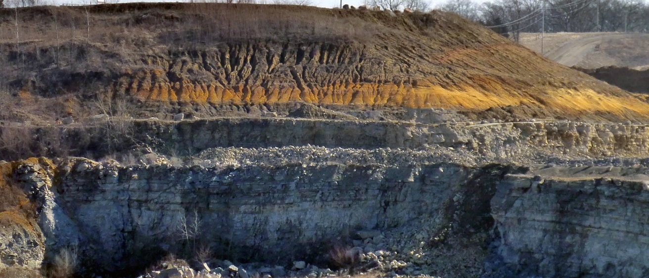
Mississippian Bedrock Stratigraphy
Sponsor: U.S. Geological Survey
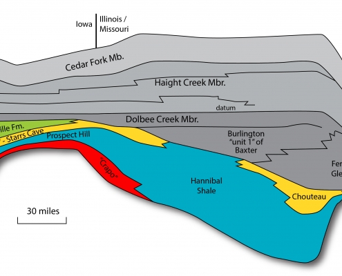
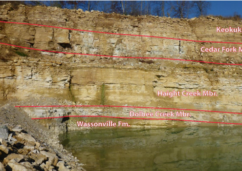
Background: The 2010 bedrock map grouped many stratigraphic formations of the Mississippian Subsystem (355–325 million years old) together, such as the Warsaw, Keokuk, and Burlington formations (Augusta Group) and the Wassonville, Prospect Hill, and McCraney formations (Kinderhookian).
Goals: Better understand, document, and map this formation.
IGS Strategies: Conduct a detailed analysis of the lithologic characteristics of these units in order to map them.
More Information: Southeast Iowa hosts several key type sections of the Mississippian, including the Keokuk, Burlington, Wassonville, and the Prospect Hill formations. The Kinderhookian type area, including the type section of the McCraney Formation, is located in west-central Illinois. Just across the Mississippi River from Kinderhook, Ill., are the type sections of other key lower Mississippian strata, the Hannibal Formation (Hannibal, Mo.) and the Louisiana Formation (Louisiana, Mo.).Correlation of the lower Mississippian strata in the tristate area has been the subject of decades of research with many questions remaining. IGS geologists are collaborating with Bradley Cramer and UI students to further research the stratigraphic enigmas that punctuate the Lower Mississippian Subsystem.Currently, the use of biostratigraphy and chemostratigraphy are leading to new insights on how the Kinderhookian in particular fits within the framework of the tristate area. Preliminary results of carbon isotopic analyses confirm that the Kinderhook-Osage boundary excursion represents a regional unconformity and a significant gap in deposition. Preliminary results of conodont sampling suggest that the McCraney Formation in southeast Iowa is, at least in part, correlative with the Louisiana Formation, and that the upper “McCraney” and the Prospect Hill formations in southeast Iowa correlate with the Hannibal Formation. This research will hopefully lead to a refined stratigraphic framework of the Lower Mississippian Subsystem in the tristate area and assist IGS geologists with making more accurate geologic maps in the near future.
Services
- Geologic mapping
- Aggregate resource potential
- Hazards investigations
Contact Us

Stephanie Tassier-Surine
Geologist, STATEMAP Coordinator
Quaternary Geology
319-335-3679
stephanie-tassier-surine@uiowa.edu

Ryan Clark
Geologist
Bedrock Geology and Mineral Resources
319-335-4024
ryan-j-clark@uiowa.edu