The icy grip of continental glaciers was one of the most significant geologic processes to affect the Iowa landscape. Most of the deposits underlying today’s land surface are composed of material known as till that was moved here by glaciers.
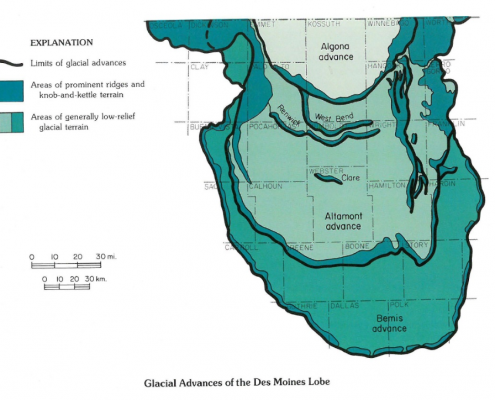
The arrival of these glaciers in the state began over two million years ago, and numerous reappearances are recorded in the deposits they left behind. For all of this massive effort, however, only the landscapes of north~central Iowa still display the actual shapes that resulted directly from glacial action. This region, known as the Des Moines Lobe, is the part of the state last touched by the huge sheets of frozen water that invaded Iowa in the past. This last glacial episode occurred only 12,000 to 14,000 years ago.
The relatively recent date of this geologic event, as compared to older glacial episodes, provides a more detailed record of its existence as well as a much clearer picture of how the glacier behaved while it was here. In recent years geologists have mapped and studied the details of the Des Moines Lobe landforms, including not only their geographic distribution but the grain size, mineral content, and internal structures of their underlying deposits. This important work advances our understanding of glacial processes and their contribution to the evolution of north-central Iowa landscapes. In
addition, such research provides valuable technical information used to predict the engineering, agricultural, and hydrologic properties of these deposits. This information has direct application for those who construct buildings, manage farms, need to locate groundwater supplies, or evaluate wastedisposal sites. These detailed studies reveal a complex but systematic assemblage of landforms that reflect dynamic environments of glacial activity through time across different parts of the Des Moines Lobe.
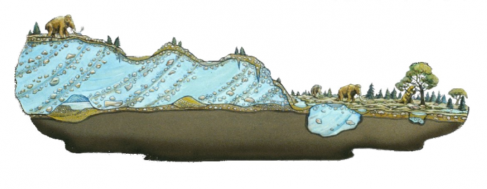
The picture of glacial activity that emerges is one of a surging ice front rapidly expanding into Iowa from a center of activity along the southern margin of the vast Wisconsinan ice sheet that lay across North America. The Des Moines Lobe advanced through North and South Dakota and Minnesota and into north central Iowa, halting at what is now the city of Des Moines and in the process establishing the present course of the Raccoon River. Today, the Iowa portion of the Des Moines Lobe is further outlined by the cities of Clear Lake, Eldora, Carroll, Storm Lake, and West Okoboji. The glacier’s advance occurred well after the period of maximum glacial cold (16,500 to 21 ,000 years ago) at these latitudes, and the moderating climatic conditions were hospitable to a richly diverse flora and fauna that inhabited meadows and woodlands along the ice margins. This episode of glacial activity, composed of at least three major surges, was followed by large-scale stagnation of the glacial ice. The process of decay and disintegration was the dominant method of ice “retreat” over large areas of the Des Moines Lobe.
A detailed chronology of the occupation of northcentral Iowa by Des Moines Lobe ice is possible because of radiocarbon dating of peat from bogs as well as logs and stumps of the spruce, hemlock, and larch that were uprooted by the advancing ice. Abundant organic-rich sediment and wood were collected at the contacts between different underlying deposits and from within the Lobe’s glacial drift. While the shrunken, relatively inactive remnants of North America’s last continental ice sheet reside today in Greenland, the behavior of more active valley glaciers can be examined in places such as Alaska and Scandinavia.
Here geologists can study modern glacial processes in an attempt to better understand the origins of glacial deposits thousands of years old elsewhere in the world. Though these valley glaciers are confined by steep mountainsides, valuable comparisons still can be made between their flow behavior and environments of sedimentation and those of glaciers in Iowa’s geologic past.
The most prominent landform patterns observed on the Des Moines Lobe are related to the major end moraines. These curved, concentric bands of ridges and hummocky terrain outline the maximum extent of active ice advances and the position of prolonged, stationary margins of stagnant ice masses. The deposits marooned around these ice margins became well-defined features of the land surface once the ice melted away. Their pattern of alignment, parallel with the outline of the Lobe, shows their origins were closely associated with the changing ice margins. The limits of three major glacial advances are marked by the Bemis, Altamont, and Algona end moraines. Within the Altamont surge, minor advances are also recorded by the Clare, Renwick, and West Bend end moraines. Their names are taken from localities where their deposits are best displayed: Bemis and Altamont are towns in South Dakota while Clare, Renwick, West Bend, and Algona are north-central Iowa communities.
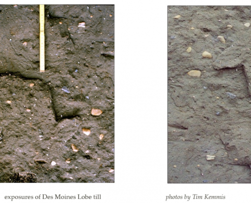
Landforms and deposits vary along these former ice margins. The portions of morainal ridges extending eastwest across the interior portion of the Lobe appear as smooth, prominent, south-facing escarpments, as much as 120 feet high. They formed along the central axis of the surging glacier, where the ice was especially mobile. This region of active oscillations of the ice front had a relatively uncomplicated history of melting. The process left behind thick deposits of compact, uniform pebbly loam called glacial till and generally produced low-relief landscapes punctuated by distinct ridges marking the limits of major ice advances. These ridge fronts are easily seen where the Altamont end moraine crosses Greene and western Boone counties and farther north where the younger Algona end moraine crosses eastern Palo Alto, Kossuth, and western Hancock counties.
As these morainal ridges begin to curve along the lateral margins of the Lobe into a more north-south orientation toward the Iowa-Minnesota border, they grade, sometimes abruptly, into broader belts of rough hummocky topography, especially in the northwestern and northeastern portions of the Lobe. This rumpled terrain, also called knob-and-kettle topography, is particularly prominent in Dickinson and adjacent parts of Emmet, Palo Alto, and Clay counties and, on the opposite side of the Lobe, in eastern Winnebago and central Hancock and Cerro Gordo counties.
These landscapes suggest that the lateral margins ofthe ice lobe moved more slowly and caused the ice flow to become tightly compressed. As a result, the debris normally transported near the glacier’s base was forced upward along zones of shearing fracture and flow within the ice and eventually melted out onto the ice surface. There the glacier’s load sometimes mixed with meltwater to form mud flows; it was also redeposited in meltwater channels and pools on the ice surface; and it was subject to slumping, deformation, and collapse as the underlying ice slowly disintegrated. The resulting deposits are composed of the usual dense pebbly loam near the bottom. This foundation of basal till, however, is veneered with stony heaps of uneven hummocky deposits that may include sandy loams, water-sorted sands and gravels, or lake-deposited silts and clays-all of which can change quickly over short vertical and horizontal distances. The jumbled hills, ridges, and swales further suggest that this slow-moving or stagnant glacial ice was continuously present in this portion of the Des Moines Lobe. Also, some of these landform patterns are composites; they combine the topographic effects of the earlier Bemis iceadvance with those of the overriding Altamont and Algona ice advances.
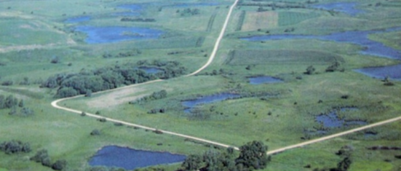
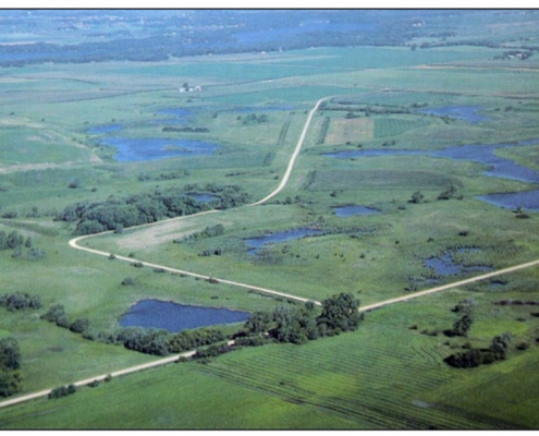
As the stagnant ice wasted away from north-central Iowa following the various surge advances, cavities and tunnels formed within and beneath the ice, some of which were linked to the glacier’s surface. These icewalled conduits served as drainageways for meltwater and glacial debris. The larger deeper portions of these networks were probably open throughout the year, while the smaller upper portions were frozen shut and redeveloped each spring in new locations. In time these drainage systems collapsed and disintegrated, resulting in hummocky topography. The larger, more permanent segments of the systems became sites of the Lobe’s presentday rivers and some of its larger lakes. The collapse of smaller segments of the karst-like systems in the ice led to the development of shallower upland swales and depressions. The irregular concentration of glacial debris that did not get flushed from these networks resulted in saddle-like ridges which separated segments of the system into kettle-like basins. Many of the smaller kettle lakes, prairie potholes, and other depressions and lowlands on the Des Moines Lobe actually display a subtly linked surface drainage pattern. One of the most significant and unexpected findings to emerge from recent detailed mapping of the maze of landforms and deposits across the Des Moines Lobe is this pattern of connected drainage routes.
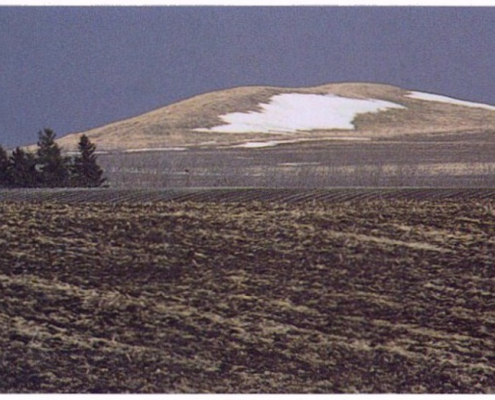
Other local characteristics of the lingering ice mass contributed to the irregular pattern of landforms and deposits. Many landform features inherited from patterns and processes of ice decay remain visible on the land surface. For example, some large crevices and chambers within the ice that were open to the glacier’s melting surface became filled with water-transported deposits of sand and gravel. These gravelly fillings exist on today’s landscape as isolated, roughly conical hills called kames. Ocheyedan Mound State Preserve in Osceola County, Pilot Knob State Park in Hancock County, and Pilot Mound State Forest in Boone County are excellent examples of kames. Similarly, the courses of streams confined in tunnels at the base of the ice sometimes clogged with sand and gravel. These alluvial-filled channels, relics of rivers that flowed beneath the ice, are seen today as narrow, winding ridges called eskers. While rare in Iowa, both Cayler Prairie State Preserve and Koppen Prairie near Grovers Lake in Dickinson County exhibit the crooked ridge forms marking the traces of these subglacial drainageways.
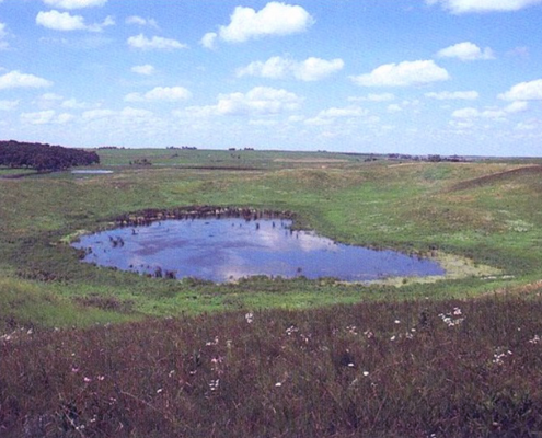
The reverse of these patterns is seen in the steepsided, bowl-shaped depressions called kettles which dimple the present land surface. Kettles mark the positions of large, isolated blocks of relatively clean glacial ice which melted slowly and perhaps were buried and protected by a thin cover of soil and rock rubble. The impressive, crater-like form of the Freda Haffner Kettlehole, a state preserve in Dickinson County, developed by this process. These features have no surface drainage outlets. Organic deposits that have accumulated in the bottoms of closed depressions include microscopic grains of pollen from the vegetation that has covered the kettle’s sideslopes and surroundings during the geologic past. Examination of this fossil material can be used to reconstruct the sequence of plant cover and related climatic change in the surrounding geographic area from the time the ice melted to the present.
It is important to realize that Iowa’s end moraines are not uniform or consistent in their appearance or composition because so many different environments of deposition existed along a single ice border. Consequently, these features do not conform to the classic “recessional” moraines caused by active and repeated glacial advance and retreat, which was more common in states to the north and east of Iowa and previously was used to explain the origin of Des Moines Lobe moraines. Instead, we see rapid glacial advances into a moderating climate in north-central Iowa, followed by regional stagnation of the ice-a picture more consistent with surge-type glacial activity. The two broad categories of “ground moraine” and “end moraine” previously mapped in Iowa are not adequate to describe what really happened here, nor do they account for the variety of landforms and deposits that remain.
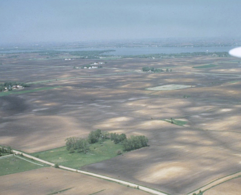
Between these various ice-marginal landscapes, other features and deposits have been identified. For example, behind the morainal ridges, numerous subtle sets of narrow, parallel ridge systems sometimes occur over large areas. These low-relief, slightly irregular landscapes are described as having “washboard” or “swell and swale” topography. Such minor-moraine crests, which are spaced about 350 feet apart and may rise no more than 5 feet, are barely perceptible on the ground; however, their patterns are clearly visible in aerial photographs, such as those of Story and Hardin counties.
Other identified features include sites of once large but now extinct glacial lakes, which are seen today as broad flats covering hundreds of square miles in southern Kossuth and Hancock counties (glacial Lake Jones) and also in a band through Wright, Hamilton, and southern Webster counties (glacial Lake Wright). In addition, extensive outwash deposits of sand and gravel carried and sorted by meltwater floods are found in front of some of the prominent end moraines along former overflow channels and glacial meltwater routes that are now the courses of such rivers as the Cedar, Shell Rock, Iowa, Skunk, Des Moines, Raccoon, Boyer, and Little Sioux. In fact, the Little Sioux River basin doubled in size following the Des Moines Lobe glacial blockage of Mississippi-bound rivers in northwest Iowa. This diverted drainage caused the temporary filling of another glacial lake (Lake Spencer) along the ice margin and the catastrophic overflow, downcutting, and permanent rerouting of these waters into the Missouri drainage system.
There are only a handful of major valleys on the Des Moines Lobe, and these are deep and narrow owing to their rapid excavation by swift meltwaters. The Des Moines River, in the most prominent of these valleys, flows roughly down the axis of the Des Moines Lobe landform region. The steep-sided valley, cut into Pennsylvanian bedrock, is dammed to hold back some of the river’s flow, forming Saylorville Reservoir, the only major artificial lake on the Des Moines Lobe. Some uneroded remnants of the valley’s outwash deposits occur as terraces perched along the valley sides. These features are often sites of commercial sand-and-gravel production, both on and off the Lobe. Terraces also contain important geologic records of successive episodes of postglacial erosion and deposition which occurred in response to melting of ice from north-central Iowa. The valley of Brushy Creek, a tributary of the Des Moines River in Webster County, hosts a prominent series of these topographic features spanning the entire evolution of the valley from over 11 ,000 years ago to the period of EuroAmerican settlement about 150 years ago. These young valleys are the only large-scale erosional features to be seen on the Des Moines Lobe. All other major landscape features were constructed by glacial ice or some related activity and thus are quite different from landscape shapes seen elsewhere in Iowa.
Nearly all of Iowa’s natural lakes occur on the Des Moines Lobe, and they are noticeably clustered among the knobby hills close to the Minnesota border. Storm Lake, Lake Okoboji, Spirit Lake, Clear Lake, and numerous smaller ponds, sloughs, and bogs are characteristic of young, postglacial landscapes and their sluggish, inefficient drainage networks. The Iowa “Great Lakes” have been a popular vacationing area since the middle of the nineteenth century. These lakes, along with ponds and marshes sometimes referred to as prairie potholes, provide valuable wildlife habitat. The historic attraction of these wetlands for great flocks of nesting and migrating waterfowl is reflected in the names given to the Des Moines Lobe towns of Mallard, Plover, and Curlew in Palo Alto and Pocahontas counties.
Deposits of peat, another natural resource tied to the state’s glacial history, often accumulated in the smaller pond, slough, and bog environments where plant material could not completely decompose. Peat deposits also occur in the form of fens, one of the state’s more unusual wetland types. At these isolated hillslope sites, groundwater seeping to the land surface has maintained permanently saturated deposits of peat for thousands of years. The spring-fed habitats support a unique wetland biota, including a number of the state’s rare plants. Fens on the Des Moines Lobe are clustered in the hummocky, end-moraine topography in the northwestern portion of the region. Silver Lake Fen State Preserve in Dickinson County is an outstanding example of these unusual geologic and hydrologic phenomena.
Though good for wetland habitat, incomplete surface drainage is a serious impediment to agricultural productivity. Many of the region’s native wetlands were drained as agriculture became more important. Today, numerous low spots contain poorly drained, dark-colored soils indicating sites of previously ponded water and abundant organic accumulations. Glacial erratics, those travel worn cobbles and boulders from out of state, are other impediments to agriculture on the Lobe. These prominent relics of glacial activity are seen strewn high and low across the landscape or purposefully gathered into field corners and along fencerows by farmers. Clearing fields of erratics and laying tile lines beneath poorly drained areas have turned the Des Moines Lobe into highly productive farmland. Satellite images of Iowa taken from space, especially in the spring of the year, show a sharp contrast between the intensive cultivation of the productive wetland and prairie soils on the Des Moines Lobe and the different land-use patterns on the more varied soil types of surrounding landform regions.
All of the glacial deposits that accumulated from the Des Moines Lobe surges and melting are referred to as the Dows Formation, named for exposures in a quarry near that town on the border of Franklin and Wright counties. Buried beneath the 45 to 60 feet of this glacial drift are several older deposits, including Wisconsinan loess, drift from an earlier episode of Wisconsinan glaciation (the Sheldon Creek Formation, exposed at the surface over part of the Northwest Iowa Plains), various buried paleosols, older Pre-lllinoian glacial deposits, and eventually Cretaceous and Paleozoic bedrock. Sandand-gravel deposits that occur along the stream valleys mentioned earlier and within the various glacial drifts are potential sources of shallow groundwater for wells in this region. Deeper supplies are available from sandstone or limestone aquifers in the bedrock below.
The grain size and the clay and carbonate mineralogy of the Dows Formation are related to the geographic sources of its ice-transported deposits. As the Des Moines Lobe moved southeasterly across southern Canada, the Dakotas, and Minnesota, it passed over large areas of fine-grained Cretaceous bedrock, especially clayrich shales and mudstones. Abundant fragments of Cretaceous shale are conspicuous in the Des Moines Lobe glacial deposits. In the field , this obvious characteristichelps distinguish this till from the older Pre-Illinoian tills that underlie the Des Moines Lobe and form the uppermost till deposits in most other regions of the state.
In summary, the uniqueness of this landform region results from its geologically recent encounter with a surging outbreak of ice along the shifting margins of a massive continental glacier. Because this final appearance of glaciers in Iowa took place during and after the period of greatest loess deposition (see next section), the Des Moines Lobe lacks a cover of windblown silt. The result is an exceptionally clear picture of the land surface nearly as the ice left it. In the 11,000 to 12,000 years that have passed since the ice melted, weathering and erosion have made some progress in modifying the landscape. However, the landforms of the Des Moines Lobe still retain the distinct imprints of recent glacial occupation.
Author: Jean C. Prior
Edited by: Drew Hutchinson
This information is based on the book Landforms of Iowa, by Jean C. Prior, published by the University of Iowa Press, Iowa City, in 1991. The book was designed and illustrated by Patricia J. Lohmann.