Sweeping, outstretched landscapes span a large area of the northeastern quarter of Iowa. This relaxed, open topographic style is free of the strong expressions of glacier surges, silt-laden winds, or erosional sculpture that identify the Des Moines Lobe, the Loess Hills, and the Southern Iowa Drift Plain.
Part of the individuality of this particular landform region lies in its topographic restraint and subtle land shapes. The tendency not to draw attention to itself also suggests that the region’s landscape features and deposits do not offer an easily recognized geological explanation for their appearance. In fact, the region was a focus of much scientific controversy until new research methods and the concept of stepped erosion surfaces were used in the 1960s to challenge the generally accepted existence of a separate sheet of Wisconsinan glacial drift in this area.
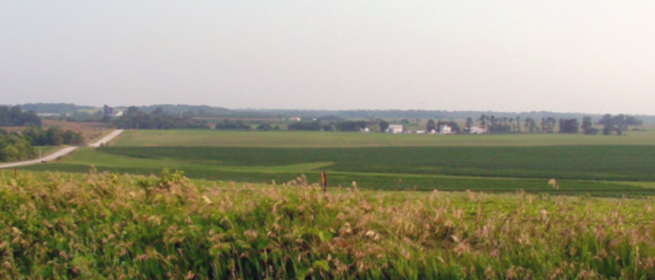
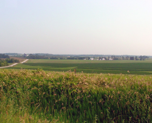
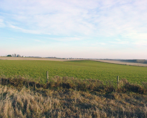
The physical characteristics of this landform region, identified now as the Iowan Surface, contain numerous clues to an elusive chapter of Iowa’s glacial history. The land surface usually appears slightly inclined to gently rolling with long slopes, low relief, and open views to the horizon. This contrasts sharply with the restricted lines of sight noted within the more billowy, steeply rolling landscapes of the Southern Iowa Drift Plain. Like southern Iowa, however, the hillslopes of the Iowan Surface can be described as having multi-leveled or stepped surfaces. These levels, though subdued, occur in a gradual progression from the major stream valleys outward toward the low crests that mark their drainage divides. It is difficult to pick out a clearly defined valley edge; more often the eye sees only a series of long slopes merging almost imperceptibly with a gentle rise to the next watershed divide. Drainage networks are well established, though stream gradients usually are low and some scattered areas of poor drainage and original wetlands occur. The low-relief landscapes offer very few exposures of their internal composition.
Erosion on a large scale is the key to the geological origins of the Iowan Surface. Earlier in its landscape evolution, before the Wisconsinan glacial events, the region was actually part of the Southern Iowa Drift Plain. It was last visited by glaciers in Pre-Illinoian time and since then has lain exposed to various episodes of weathering and soil development, erosion, and loess deposition. We have already seen that past erosional activity in Iowa has not been uniform through time and that episodes of more accelerated erosion have cut broad steps or levels into the slopes of the state’s watersheds. One of the latest of these episodes occurred between 16,500 and 21,000 years ago during the coldest part of the Wisconsinan, just as the continental ice sheet was becoming fully expanded. In the area of the Iowan Surface, the intensity of this cold-climate weathering and erosion simply overwhelmed the earlier landscape contours. Earth materials were loosened, removed, and redeposited across virtually the entire landscape, leaving only scattered uneroded remnants of higher ground.
Fossil remains of arctic and subarctic species of plants, insects (especially beetles), small mammals, and snails have been recovered from organic-rich sediment in eastern Iowa glacial deposits dating from this interval. The fossil assemblage, remarkably close to flora and fauna living in northern Canada today, provides evidence that tundra conditions were well established in Iowa 17,000 years ago. During this time, climatic conditions were substantially colder and wetter than they are at present. Extensive freeze-thaw action, massive dislodgement of loosened material, sheetwash of slopes, and turbulent winds were forms of erosional scouring that took place throughout the cold but ice-free tundra-covered areas of the upper Midwest. The effect of these periglacial climatic conditions and geologic processes was to vigorously plane the deeply eroded landscapes across northern Iowa, the area in closest proximity to the spreading ice front. Under these conditions, hillslopes became very unstable and were worn down as the land slumped and washed. The Pre-Illinoian upland summits and divides were lowered, and the Yarmouth-Sangamon and LateSangamon paleosols were almost completely stripped from the landscape.
The most pronounced topographic effects of this erosional scrubbing of the landscape occurred in the northern half of the state, reflecting the colder, more severe climatic conditions. The effects of this erosional episode, however, also spread into southern Iowa but with less noticeable results. In the Southern Iowa Drift Plain, this erosion surface is seen only as a minor leveling of the landscape along the lower slopes of watersheds. Furthermore, the low-relief Iowan Surface often is noticeably inset below the steeply rolling landscapes of the Southern Iowa Drift Plain, a relationship best observed where the two regional boundaries are in sharp contact. A north-south trip through Benton County in the vicinity of Blairstown, for example, offers a good view of these contrasting landscapes and their relative differences in elevation.
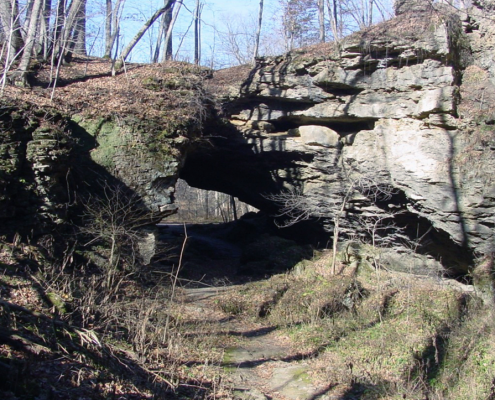
In north-central Iowa, this widespread erosion surface was later overridden by the Des Moines Lobe ice sheet, whose deposits and landforms mark the western border of the Iowan Surface. To the east, the Paleozoic Plateau contains only isolated pockets of any Pre-Illinoian glacial deposits. The border between the Paleozoic Plateau and the Iowan Surface is marked by the Silurian Escarpment, a massive leading edge of Silurian-age strata that reflects a major difference in erodibility between geologic materials on either side of the boundary. The southern border of the Iowan Surface is very irregular, as it is crossed in numerous places by major northwest-to-southeast trending stream valleys. The border is further masked by an increasing thickness of windblown loess and sand, which originated from these valleys as they were filling with glacial meltwater and sediment. So, while the Iowan Surface has a distinctive topography and a mappable boundary, many of its characteristics actually continue to be expressed beyond its borders, though buried beneath younger deposits in the case of the Des Moines Lobe to the west, or taken over by more expressive bedrock materials in the case of the Paleozoic Plateau to the east, or diminished by increasing distance away from the latitudes of greatest climatic intensity in the case of the Southern Iowa Drift Plain. The result is that the Iowan Surface is a regional window through which we view the great reduction in topographic relief that was imposed by erosion on the landscapes and Prelllinoian glacial deposits of northern Iowa.
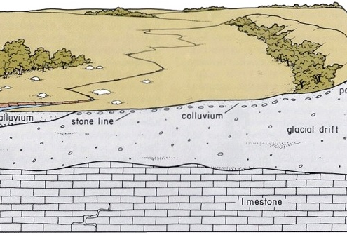
Loess deposition was also under way during this time but for the most part loess could not accumulate on the rapidly evolving landscape in the face of such corrosive erosional activity. Only toward the end of this episode did a thin, discontinuous deposit of loess manage to stay in place on the land surface, primarily in the southern part of the region. In addition, the more resistant pebbles and cobbles from the glacial drift lagged behind on the eroded slopes. This residual stone line or pebble band is a commonly observed stratigraphic feature where roadcuts or quarries expose cross-sectional views of the eroded drift surface and the thin loess or loamy sediment that may cover it.
Other features typical of the Iowan Surface are the ever-present fieldstones known as glacial erratics. Composed of igneous and metamorphic rock types that form the bedrock foundations of Canada, Minnesota, and Wisconsin, they were part of the great volumes of rock and soil material scooped up by the advancing Pre-Illinoian glaciers and suspended within the frozen masses of moving ice. Eventually released by glacial melting, these travel-worn boulders are now stranded far south of their native areas. Great numbers of glacial erratics are observed across the Iowan Surface, especially along its shallow valleys, indicating the boulders’ resistant composition withstood the erosional wear and tear that removed so much of the softer, clay-rich deposits that once enclosed them.
Though more recently deposited glacial erratics are also common on the Des Moines Lobe, it is the unusual size of many Iowan Surface boulders that characterizes this region. Many of the largest erratics have been broken apart by dynamite for use in building foundations or simply to remove them from cropped fields. Some examples of the few remaining large erratics can be seen in the city park at Nora Springs, in a farm field along Floyd County route T-70 three miles west of Nashua, along a gravel road one mile south of U.S. 20 on the Grundy-Black Hawk county line five miles west of Cedar Falls, and at St. Peter’s Rock three miles southeast of Alta Vista in Chickasaw County. A large granite boulder also is present in Grammer Grove, a wooded Marshall County wildlife area near Liscomb. Well drillers throughout the region occasionally report unexpected encounters with enormous buried erratics that resist drill bits and require moving well sites some distance away.
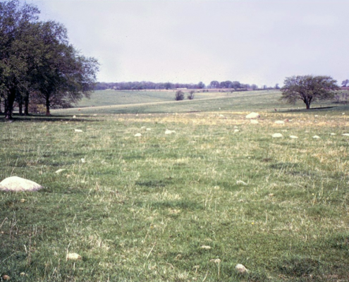
Smaller erratics continue to work upward to the land surface during seasonal freezes and thaws. They are well known to farmers in the region, who often haul them to unused field corners or pile them along fence lines. Pastures in Chickasaw, Bremer, Butler, Buchanan, and Black Hawk counties are good places to look for undisturbed boulder-strewn landscapes. Glacial erratics, though present, are less commonly seen in the Southern Iowa Drift Plain because of the loess cover and the slower geological progress in eroding the glacial drift that surrounds them. Glacial boulders in that region are usually seen in ravines and valleys where downcutting by streams has exposed them.
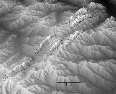
In the southern third of the Iowan Surface, slopes steepen near the larger stream valleys. Elongated ridges and isolated oblong hills known as paha occasionally rise prominently (30 to 100 feet) above the surrounding plains. The term “paha” comes from Dakota Sioux dialect meaning ” hill” or “ridge,” and it was first applied in 1891 by W.J. McGee to the special hill forms in this region of Iowa. These streamlined landscape features, mantled with silt and sand, are concentrated along the region’s irregular southern border and are distinctly oriented in a northwest-to-southeast direction. Eighty percent of the 116 paha mapped in this region are within 22 to 50 miles of the southern border. Their distribution and alignment parallel to (and often very near) river valleys strongly suggest that paha are actually wind-aligned dunes that accumulated in response to the strong, prevailing northwest winds that were scouring the Iowan Surface during this period of glacial cold. The paha formed and migrated in close proximity to those valleys that supplied abundant amounts of loose sand and silt. Their solitary landscape positions close to the southern border of the region also indicate that, at least locally, rapid accumulations of massive amounts of loess managed to stay ahead of the wasting landscape and protect the older glacial deposits underneath from further erosion.
Paha also occur along interstream divides, which along with the sequence of materials identified in drilled core-samples taken from their interiors, further confirms their origins as erosional remnants preserved by thick windblown deposits. Paha are the last topographic and stratigraphic remains of uplands that were once part of a higher, older, continuous Pre-lllinoian glacial plain. Internally, the paha are underlain by Pre-Illinoian tills, many with a well-developed gray (Yarmouth-Sangamon) or reddish (Late-Sangamon) paleosol still intact at the top. As noted, they are capped with a thick interval of loess and often sand. This is the same stratigraphic sequence normally found throughout the uplands of the Southern Iowa Drift Plain.
Soils, especially those mapped on the larger paha, indicate the subsequent native vegetation of these elevated sites was forest rather than prairie. Perhaps the prairie fires that maintained the surrounding grasslands detoured around these hilltop positions just as they bypassed low-lying wooded river valleys across the state. Also noted on larger paha are differences in permeability between the more porous loess and sand and the underlying clay-rich paleosol and glacial till. These hydrologic conditions produce occasional hillside seeps, just as was noted among southern Iowa’s landscapes. Casey’s Paha (Hickory Hills Park) in northern Tama County and the campuses of Cornell College in Mount Vernon and Kirkwood Community College in Cedar Rapids are prominent paha landmarks in eastern Iowa and are good examples of McGee’s “graceful, dolphin-backed hills.”
Only a few scattered paha occur in the northern two-thirds of the Iowan Surface. In fact, the remaining glacial deposits of this area are quite thin, and the influence of shallow limestone bedrock is seen on the land surface in the form of karst features, especially sinkholes. Good examples of sinkholes, where cavities in the underlying Devonian limestone resulted in collapse of the land surface, are seen in farm fields along U.S. 218 north of the town of Floyd in Floyd County. Sinkholes and broad sags in the landscape, where karst conditions are just beginning to show above shallow fractured limestone, make this intensively cultivated region especially vulnerable to groundwater contamination. As we will see, the effect of underlying bedrock on the landscape is magnified considerably in the Paleozoic Plateau, which is that much closer to the influence of the Mississippi Valley.
Limestone and dolomite deposits in the eastern half of Iowa are abundant, and their high quality and relatively shallow depth support an important economic mineral industry in this part of the state. Rock quarries excavated into Silurian and Devonian formations are especially common within the Iowan Surface where these bedrock units usually are not too deeply buried by glacial materials. The carbonate rocks also provide substantial quantities of groundwater to wells throughout the region. Because of the thin glacial drift, the contributions of groundwater discharge from these bedrock aquifers to the streambeds maintain the flow of major rivers such as the Winnebago, Shell Rock, Cedar, and Wapsipinicon during dry conditions.
Groundwater flow also sustains unusual local wetlands known as fens. These water-saturated peat deposits, supporting some of the state’s rare plant communities, were described earlier as being clustered in the northwestern part of the Des Moines Lobe. Fens are also present, though much more widely scattered, among the gentle slopes of the Iowan Surface.
In the past, the surface deposits of this region were regarded as glacial drift from a Wisconsinan ice advance into Iowa prior to the Des Moines Lobe. The paha were regarded as possible mounds of till molded by that advance or as high areas bypassed by thin glacial ice. Improved research methods based on core-drilling transects across the landscape proved convincingly that these theories were not true and that the so-called “Iowan drift” does not exist. This region evolved not from glacial deposition but from normal processes of erosion in cold environments where frost action, downslope movement of water-soaked soil materials, and strong winds were the dominant geologic processes at work.
Author: Jean C. Prior
Edited by: Drew Hutchinson
This information is based on the book Landforms of Iowa, by Jean C. Prior, published by the University of Iowa Press, Iowa City, in 1991. The book was designed and illustrated by Patricia J. Lohmann.