
Broken Kettle Grasslands. Photo by Michael Leland.
Irregularities in the landscape always catch the eye. These differences in elevation are described as the land’s relief, a trait that accounts for much of a visitor’s first impression of a new place. For visitors to western Iowa’s Loess Hills, the scenic relief makes a lasting impression.
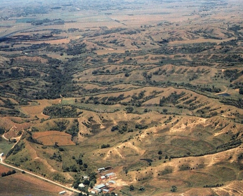
The irregular Loess Hills form one of the state’s most distinctive landscapes. They extend in a narrow band that borders the full length of the Missouri River valley in western Iowa. In the heart of the deep-loess landscapes, usually within two to ten miles of the Missouri Valley, the topography is sharp-featured, with alternating peaks and saddles that dip and climb along narrow, crooked ridge crests. Numerous shorter sidespurs branch off the main ridges, and the steeper slopes of both are often horizontally scored with a series of stair-like steps. A dense network of drainageways forming closed-in hollows, narrow ravines, and steep-sided gullies contributes to the intricately carved terrain.
The western boundary of this region is very abrupt, as distinct and well defined as a coastline. The bluffs of steeply pitched, prairie-covered ridges and wooded backslopes stand boldly apart from the lower, flat-lying cultivated fields of the Missouri River valley floor. Some of the most scenic vistas in Iowa appear from ridgetop summits that overlook the boundary between these two contrasting regions. The eastern boundary of the Loess Hills is not easily defined, as the hills merge gradually with the more rolling landscapes of the Southern Iowa Drift Plain. Three state parks—Stone, Preparation Canyon, and Waubonsie—offer good access to the typical landscapes of the Loess Hills.
The hills are composed of a gritty yellowish to grayish tan sediment known as loess. Loess is a wind-deposited silt (often including some sand and clay) composed predominantly of closely packed grains of quartz. These deposits in western Iowa are porous, lightweight, and easily eroded. They are vulnerable to collapse when wet yet are quite cohesive when dry, and they exhibit sheer, nearly vertical faces that tend to form slabs, columns, and vertical tunnels or pipes as they erode. As unusual as these hills appear, loess itself is not a rare or unusual material. In fact, tens of thousands of square miles of the midwestern United States are covered with it. Loess is the parent material throughout broad areas of the nation’s most productive agricultural soils. Extensive loess deposits occur along the lower Mississippi valley, along the Platte River valley of the Great Plains, and in the Palouse district of eastern Washington, as well as in central Europe, the Soviet Union, and northern China. Many of these deposits are associated with major river-valley sources, as they are in western Iowa.
The word “loess,” usually pronounced to rhyme with “fuss,” is German in origin and was first used along the valley of the Rhine River to describe the same types of massive silt deposits. In the early geologic literature of the western Iowa counties, loess was referred to as “silicious marl” or the “Bluff Deposit,” and the silt was thought to have originated as a water-laid sediment in a large lake. It was Bohumil Shimek, a well-known 19th-century Iowa naturalist studying the fossil remains of air-breathing snails found in Harrison and Monona counties’ hills, who first correctly recognized loess as a wind-deposited material.
The deposition of loess was a widespread side effect of Pleistocene glacial activity. Abundant silt and clay in the bedrock along the routes of glacial advance as well as the rigors of glacial transport produced the fine-grained particles. During ice melting, the pulverized debris was released into meltwater streams that drained the ice fronts. During late-glacial time in particular, from about 31,000 to 12,500 years ago, the Missouri valley served as a major channelway for large volumes of meltwater and sediment released from the vast Wisconsinan ice sheet draped across north-central United States.
The region of deep loess in Iowa coincides closely with the wide north-south segment of the Missouri River valley, roughly from Sioux City to Kansas City. It was from this broad valley that windborne silts were swept aloft from floodplains clogged with outwash brought south by seasonally swollen floods of glacial meltwater.
The process of loess accumulation took place in varying degrees along all major midwestern valleys that carried glacial meltwater. In western Iowa, however, a combination of abundant fine-grained outwash material, broad valley width, and climatic conditions allowed unusually thick deposits of loess to accumulate. Loess deposition gradually ceased as the discharge of glacial outwash into Iowa’s rivers slowed.
While loess deposits are thickest in Iowa and northwestern Missouri, thinner deposits occur on the opposite side of the valley in Kansas, Nebraska, and South Dakota as a result of natural variations in wind direction. The deposits in Iowa, however, are thick enough to obscure the older relief of the pre-existing land surface and give their own form to the modern landscape. The resulting terrain is rare among the world’s landscapes. Only in the corresponding latitudes of China, along the valley of the Yellow River where massive deposits of loess occur, are thousands of square miles of similar landscapes known to exist. The process of loess deposition is seen today in Alaska along such rivers as the Copper and Matanuska, which drain large valley glaciers in the Chugach Mountains along the south-central coast. Though such conditions no longer exist in Iowa, the dry Dust Bowl years of the 1930s or the yellowish brown haze filtering the sun on a windy day during spring planting are reminders of the continuing ability of the wind to sort and move the Earth’s grit.
The thickness of loess in the Loess Hills is generally more than 60 feet, and depths of 150 to 200 feet have been recorded locally from water-well drilling records and outcrop study. It is difficult to say how much the present appearance of the dune-like, corrugated landscape resulted from the action of wind during deposition. It is clear, however, that many streams within the hills remained active during loess deposition and that much of the easily eroded material has been reworked or removed altogether in the last several thousand years. Erosion has been a major factor in shaping the loess deposits. The intricate, finely sculpted Loess Hills topography is a product of the combined effects of wind deposition, erosional processes along entrenched stream systems, and gravity-induced slumping of thick, fine-grained sediment.
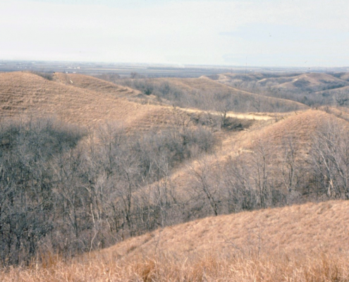
The high-relief terrain within this region has tended to isolate its distinctive landforms from encroachment by agriculture and urbanization and thus protect sizable tracts of its original prairie. The hills harbor a rich mosaic of specialized ecological niches because of the strong local contrasts in soil moisture, temperature, evaporation, slope angle, and exposure. The dry ridgetops and exposed southwest-facing slopes sustain distinctive shortgrass prairie communities, including some unusual native plants and animals. The spine-leafed yucca and plains spadefoot toad, for example, are two species more typically found in desert environments farther southwest. In contrast, the more protected backslopes, lower hillslopes, and deep drainageways offer cooler, moister habitats favorable to the growth of trees and shrubs. This woodland cover has expanded rapidly over the last hundred years. Prairie fires, important to the maintenance of grassland ecosystems, were suppressed as the region became settled. These timberlands are now so extensive that they are the basis for the new Loess Hills Pioneer State Forest.
The strong connection between landforms, geological processes, and ecology in western Iowa has merited national recognition. Two separate tracts within the Loess Hills have been designated as National Natural Landmarks. This program, administered by the U.S. Department of the Interior, National Park Service, selected nearly 10,000 acres in Monona and Harrison counties as nationally significant examples of landscapes and habitats dominated by loess. The two sites in the heart of this deep-loess country include 7,440 acres north of Turin and 2,980 acres north of Little Sioux.
Three major loess deposits may be distinguished in the Loess Hills. The oldest is the Loveland, which accumulated throughout the midcontinent during Illinoian time between approximately 120,000 and 150,000 years ago. Next in sequence are the Pisgah (25,000 to 31,000 years old) and Peoria (12,500 to 25,000 years old), which correspond to younger, Wisconsinan intervals of deposition. Each of these wedge-shaped loess deposits is successively younger and more widely distributed from its Missouri Valley source area.
The Peoria loess is the thickest and most commonly seen unit in Iowa. Within this deposit are wind-shaped ripples, clues that the loess accumulated very rapidly at times. Other exposures contain thin dark bands of concentrated organic carbon, marking periods of time when little or no loess deposition took place and the land surface was exposed long enough for vegetation to gain a hold and for soil development to begin. Abundant fossil mollusks, most commonly the fragile white shells of terrestrial snails that lived on the land surface during loess deposition, are also found.
Other color and textural variations appear in loess as a result of alterations caused by weathering. Exposures sometimes show a strongly mottled or splotchy appearance caused by reddish brown iron stains; occasionally, vertical tube-shaped masses of iron called pipestems are also found. These features owe their origins to chemical responses resulting from fluctuations in the water table. Such changes in groundwater-saturated conditions prompted the segregation of iron into these color mottles or into the cylindrical deposits formed along channels of plant roots that once penetrated the loess.
Other interesting objects found within loess deposits are hard nodular pebbles known as loess kindchen (loess dolls). Composed of lime and usually rounded or elongated in shape, these nodules are most often an inch or less in diameter and are usually concentrated in zones. Occasionally they reach baseball or grapefruit size. They were formed by infiltrating rainwater and snowmelt that dissolved and leached carbonate grains present in the loess; as the water moved downward, the lime was concentrated and redeposited around some nucleus to form these unusually shaped concretions.
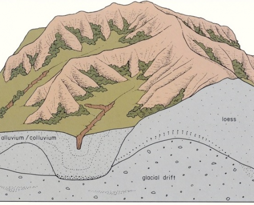
While the extraordinary thickness of loess is often emphasized, an observant visitor to this region will soon realize that other geologic materials are also present. Older deposits are exposed to view because the loess varies in thickness and in places has been removed by erosion. For example, deposits of glacial drift, including beds of sand and gravel, are frequently seen within the Loess Hills. These older deposits occur beneath the loess and accumulated during Pre-Illinoian glacial events. Abrupt changes observed along hillside profiles, from steep upper slopes to more gentle lower slopes, often coincide with these contacts between loess and underlying glacial till or sand and gravel.
The sand-and-gravel deposits, such as those exposed beneath the loess at Turin in Monona County, hold great interest for paleontologists because of the outstanding fossil remains found in them. Calvin and Shimek’s description of the so-called Aftonian fauna was the first documentation of the fascinating array of large and small vertebrates that provide important glimpses of glacial-age environments and animals in Iowa.
Perhaps one of the most unusual geologic materials encountered beneath the loess is another windblown deposit-volcanic ash. A long-studied deposit near the Harrison-Monona county line was dated at 710,000 years old. On the basis of its chemical composition, this 15-inch layer of whitish ash was determined to have originated from eruptions of now-extinct volcanoes in Yellowstone National Park. This and other western Iowa ash deposits are important keys to unlocking the ages and subdivisions of the state’s Pre-Illinoian glacial deposits, as will be seen in the next section.
Bedrock is another geologic material observed in the Loess Hills, most often in quarries along the bluffline of the Missouri Valley. In fact, the overall width of this valley is a reflection of contrasting bedrock units. The very broad valley along the northern third of the Loess Hills region is underlain by Cretaceous-age rocks consisting primarily of easily eroded shales and thin-bedded, chalky limestones containing abundant fossil clams. These bedrock materials occur quite close to the land surface in the northern Loess Hills and are easily seen in the Sioux City area. From Harrison County south, however, the region is underlain by Pennsylvanian limestones, and the Missouri Valley narrows abruptly in response to this more resistant bedrock type. The presence or absence of these various geologic materials near the land surface, combined with their uneven resistance to the lateral erosion of the Missouri River, helps explain the sweeping, crescent-shaped embayments that indent the valley’s bluffline.

Erosion in the Loess Hills deserves special mention. Much of this landscape’s unique appearance results from erosional activity coupled with the special physical properties of loess mentioned earlier. For example, erosion at the base of the bluffs along the Missouri Valley has taken place primarily through contact with flowing water. The Missouri River along much of its length in Iowa flows several miles west of the Loess Hills; however, this river or one of its tributaries clearly has swung eastward against the bluffs, gnawed at their base, carried away the collapsed loess, and left sheer slopes and an abrupt bluffline—perhaps only within the last few hundred years. In addition, ridges of loess once extended out into the valley, perpendicular to the present bluffline. These have been planed off, leaving steep, triangular-shaped faces known as truncated spurs. Older, higher floodplain levels (terraces) within the Missouri Valley also have been removed by erosion, though major tributaries such as the Soldier, Maple, and Boyer rivers still shelter these landform features and their geologic records. The principal landscape features formed along the Missouri valley margins since this erosional activity are alluvial fans. These apron-shaped deposits flare outward from smaller sediment-laden tributary streams that spill from the hills. On steep upper slopes within the hills, erosion also takes place by dislodgement of loess, encouraged by the pull of gravity. Catsteps, the striking stair-like features that mark many of the steeper slopes, result from periodic slipping and irregular downslope transfer of loess by gravity. These small slumps, good indicators of unstable slopes, also may form in response to trampling by livestock.
The physical properties of loess also contribute to a number of engineering problems and land-use hazards. For example, the style of roadcuts throughout the region reflects the capacity of exposed loess to maintain nearly vertical faces. Such excavations usually have steep single walls or are stepped back in a series of steep risers and horizontal treads. Cracks tend to develop along natural vertical partings or zones of weakness that often occur behind and parallel to these exposed faces of loess. Porosity and the natural steepness of loess slopes promote their relatively dry condition and apparent cohesiveness. During wet periods, however, when infiltrating water lubricates these vertical openings or when a rising water table saturates the base of an exposure, the seemingly stable loess can no longer bear its own weight. It collapses easily, sometimes resulting in serious landslides. Fresh scars on the landscape where these slope failures take place are prominent after heavy rains, and road-maintenance crews must periodically reopen roads blocked by slumped loess. The relocation of the War Eagle Monument on the bluffs at Sioux City was necessitated by recurring episodes of slope instability and collapse.
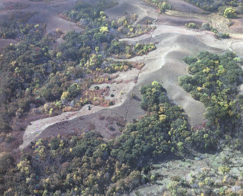
The erodibility of loess and its instability when wet pose other serious problems and land-use hazards in this region. Soil erosion rates are very high, and the amount of eroded sediment carried in streams draining the region is among the highest recorded in the United States. Gully erosion is especially pronounced, and these deep, narrow, steep-sided features are characteristic of the region’s smaller drainages (photo, left). Gullies lengthen headward, deepen, and widen quickly after rainstorms, cutting into cropland, clogging stream channels and drainage ditches, and forcing costly relocations of bridges and pipelines.
The Loess Hills are undoubtedly Iowa’s most fragile landform region in terms of susceptibility to erosion. The land is being shaped as rapidly as any terrain in the state. It is also clear from the geologic record that these dynamic episodes of erosion and deposition have been part of the scene for thousands of years. While gully erosion is intensified by stream channelization, loss of vegetation cover, overgrazing, cultivation, and other types of human disturbances, recent geological studies have shown that episodes of gully cutting and filling have occurred repeatedly during the last 25,000 years, significantly rearranging some of the thick accumulations of loess. Studies of buried gully fillings have also revealed previously unsuspected archaeological remains preserved because of these geological processes. The search for other archaeological sites can be guided by an improved understanding of the region’s landscape evolution.
The emphasis on erosion and the realization that much of its impact on the landscape is geologically quite young are important themes that will be repeated in other sections on Iowa’s landform regions.
Author: Jean C. Prior
Edited by: Drew Hutchinson

This information is based on the book Landforms of Iowa, by Jean C. Prior, published by the University of Iowa Press, Iowa City, in 1991. The book was designed and illustrated by Patricia J. Lohmann.