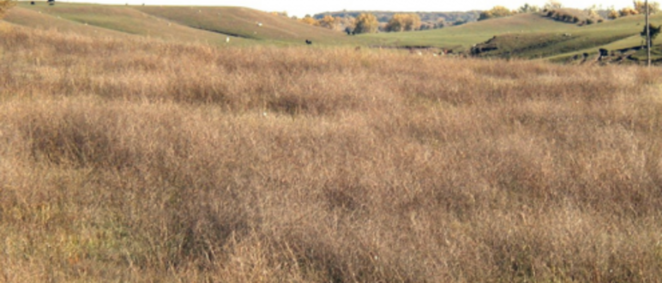
Loess-capped hills in Northern Iowa Plains, O’Brien County. Photo by Andy Assell.
The landscapes of northwest Iowa have a seasoned appearance, exhibiting a blend of terrain features and geologic materials that individually dominate other landform regions. Taken together, however, they produce a distinctive combination that sets
apart this region of the state.
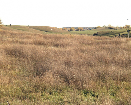
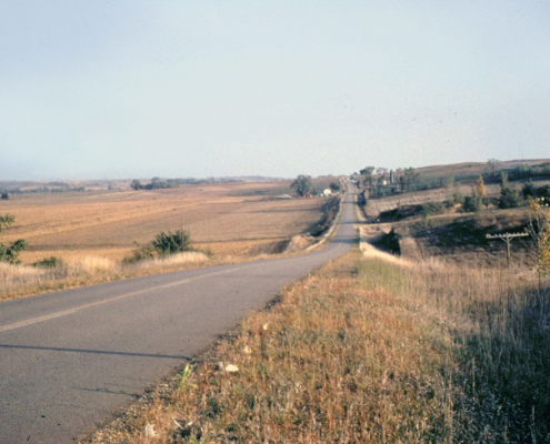
The gently rolling landscapes of the Northwest Iowa Plains are reminiscent of the low, uniform relief seen on the Iowan Surface. A well-established branching network of streams reaches out over all of northwestern Iowa, providing effective drainage and a uniformly creased land surface. Most of the valleys are wide swales that merge gradually with long, even slopes up to broad, gently rounded interstream divides. This uniform density of stream drainage is important in unifying a region where both Pre-Illinoian and Wisconsinan glacial deposits occur at the land surface.
The uplands in the western half of this region are underlain by Pre-Illinoian glacial tills that have been erosionally stripped of their paleosols. In the eastern half of the region, however, these tills are covered by younger glacial deposits. This sheet of glacial drift, mapped as the Sheldon Creek Formation, links the Northwest Iowa Plains to the Wisconsinan glacial advances displayed so vividly in the landscapes of the Des Moines Lobe to the east. The Sheldon Creek drift is also Wisconsinan in age but was deposited during an earlier glacial episode. Radiocarbon dates place the age of this older ice advance at about 20,000 to 30,000 years ago or 6,000 to 16,000 years earlier than the Des Moines Lobe advance. Deposits of the Sheldon Creek Formation continue eastward beneath the Des Moines Lobe, extending at least as far as western Franklin County where they appear in a quarry near Dows along the Iowa River. They have also been found just above water level in the deeply entrenched valley of Brushy Creek in eastern Webster County. The glacial advance(s) that deposited the Sheldon Creek drift took place just before Wisconsinan climates were at their coldest and just before massive loess deposition and intense erosional activity spread across Iowa’s ice-free, tundra-vegetated landscapes.
Even though the eastern portion of the Northwest Iowa Plains contains these Wisconsinan-age glacial deposits, it and the rest of the region fell victim to the vigorous erosive activity that accompanied the glacial cold. In the process, most of the topographic signs of a freshly glaciated landscape were lost as streams lengthened and connected to form a well-established drainage network across the landscape. Today, the eastern portion of the region no longer resembles the landscape of its glacial sibling to the east. Instead, the entire Northwest Iowa Plains region bears a strong similarity to the Iowan Surface in terms of erosional history and overall appearance. Keep in mind that the erosional events that leveled the Iowan Surface 16,500 to 21 ,000 years ago had an impact on all of northern Iowa. The effects of this erosional scouring in northwest Iowa remain apparent in the long, low, rolling swells and in the distant, uncluttered views to the horizon, even though the gentle slopes are mantled by loess. As noted earlier, these effects in north-central Iowa were later buried by the expressive glacial deposits of the Des Moines Lobe.

Glacial geology maps of the midcontinent usually show the Wisconsinan-age Des Moines Lobe advances as a composite outline of both the Sheldon Creek and the Dows formations. Mapping of the landform regions of Iowa, however, is based primarily on physical appearance or geomorphology, and this isolates the Des Moines Lobe region as only the more recent and more clearly observed of this two-stage Wisconsinan glacial activity in Iowa.
Although there are similarities in the erosional histories of the Iowan Surface and the Northwest Iowa Plains, there are important differences in the age of the affected glacial deposits, as noted, as well as in the thickness of the loess mantle, the elevations of the land surface, and the present precipitation and vegetation. It is this combination of physical characteristics that unites the Northwest Iowa Plains and distinguishes this region from the state’s other landform regions.
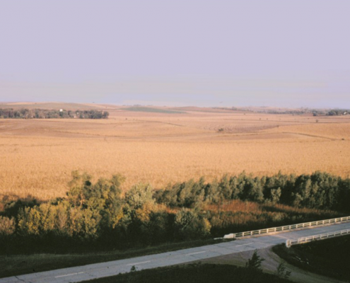
Windblown loess is abundant and nearly continuous across the region. The mantle of silt generally thins in a southwest to northeast direction from about 16 feet in Plymouth County to about 4 feet in Clay County. This depositional pattern reflects the region’s proximity to the Loess Hills and to the Missouri and Big Sioux river valleys where this fine-grained material originated. The effect of the loess mantle in northwestern Iowa is to steepen some hillslopes and smooth out and fill in irregularities elsewhere in the landscape. In addition, the pattern of loess accumulation tends to obscure the region’s boundaries with the Loess Hills to the southwest and the Southern Iowa Drift Plain to the south. The loess cover, however, does help to differentiate the Northwest Iowa Plains from the Des Moines Lobe, which has no loess deposits on the land surface.
Added to these factors of geological history and materials are subtle differences that influence the appearance of this particular landform region, such as elevation. Northwestern Iowa is a definite topographic step upward to the High Plains of the Dakotas. The lowest land surface elevation in Iowa, 480 feet, occurs in the southeastern corner of the state where the Des Moines River empties into the Mississippi. From that point, elevations gradually climb to the north and west. Iowa’s highest point of land, 1,670 feet, is in a farmer’s feedlot on a knobby ridge of glacial drift at the edge of the Des Moines Lobe about four miles northeast of Sibley in Osceola County. While this high point is actually on the northwestern edge of the Des Moines Lobe region, altitudes throughout the Northwest Iowa Plains are uniformly higher than any other portion of the state.
As these morainal ridges begin to curve along the lateral margins of the lobe into a more north-south orientation toward the Iowa-Minnesota border, they grade, sometimes abruptly, into broader belts of rough hummocky topography, especially in the northwestern and northeastern portions of the lobe. This rumpled terrain, also called knob-and-kettle topography, is particularly prominent in Dickinson and adjacent parts of Emmet, Palo Alto, and Clay counties and, on the opposite side of the lobe, in eastern Winnebago, central Hancock, and central Cerro Gordo counties.
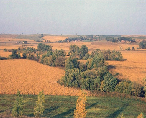
Coinciding with these regional variations in elevation are similar changes in the distribution of woodlands and precipitation. Native tracts of timber decrease noticeably from eastern Iowa to western Iowa, and in the western part of the state, they continue to decrease from south to north. Except for trees planted as windbreaks around farmsteads or those confined to the more moist drainageways, the plains of northwest Iowa are barren of timber.
A corresponding relationship is found in the statewide distribution of precipitation. The highest mean annual precipitation occurs in southeast Iowa with 34 inches per year, and the rate of precipitation progressively decreases toward the northwest corner where the mean annual precipitation drops below 25 inches per year. Thus we are looking at a landform region which, in addition to its other attributes, is higher, drier, and less timbered than any other in the state.
Bedrock exposures, rare in this part of Iowa, are generally not a factor in the appearance of the landscape. Iowa’s youngest sedimentary rocks, however, are widespread beneath the glacial deposits of the Northwest Iowa Plains. Cretaceous-age sandstone, chalk, limestone, and shale, usually concealed from view, are found in outcrops along the Big Sioux River valley in Plymouth and Sioux counties. Even younger Tertiary rocks are thought to underlie this region, as vertebrate fossils of definite Tertiary age, including rhinoceroses and three-toed horses, have been identified from Pleistocene sand-and-gravel deposits in western Iowa. The sharp edges and excellent preservation of these fossils indicate that they have not traveled far from their original burial site.
The various Cretaceous rock types include sands deposited about 100 million years ago in stream channels that drained southwesterly toward an advancing Cretaceous coastline. Marine shales and chalky limestones followed as expansion of the great interior seaway submerged the central United States from the western mountains to eastern Iowa about 90 million years ago. Vertebrate fossils from these strata in Iowa and nearby areas of South Dakota and Nebraska include skeletal fragments of fish, crocodiles, large marine reptiles (plesiosaurs, turtles), and sharks. The transitional marine, alluvial, and terrestrial environments also produced Cretaceous plant fossils, including cones and needles of conifers as well as leaf impressions from trees resembling magnolia and sycamore. Microscopic spores and pollen of mosses and abundant ferns have also been found in the Cretaceous mudstones and lignites, carbon-rich deposits intermediate between peat and coal.
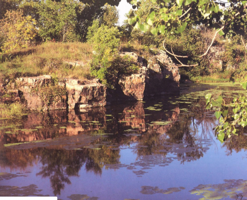
Bedrock also occurs at the land surface in the extreme northwest corner of Lyon County. Here visitors can glimpse exposures of the oldest bedrock that can be seen anywhere in Iowa Precambrian age Sioux quartzite. This hard, durable formation has a uniformly pink to reddish color. The low ridges of colorful outcrops are protected as part of Gitchie Manitou State Preserve. When examined closely, rounded grains of quartz sand tightly cemented together by silica tend to give the rock a glassy appearance. Stains of iron-oxide on surfaces of the original sand grains create the variety of pinkish to red colors. The layers of sand that compose this rock are sometimes arranged in sets of inclined or cross-bedded patterns. These reflect swiftly changing currents of shallow water that originally flowed in a complex of braided stream channels close to sea level between 1.6 and 1. 7 billion years ago. The leading edges of many of the smooth rock outcrops also display a high gloss from long exposure to the polishing action of dust-laden winds. Pale green lichens often grow over the more protected leeward rock surfaces.
Gitchie Manitou State Preserve contains the principal outcrops of Sioux quartzite that are exposed along the banks of the Big Sioux River in Iowa. In 1870, geologist Charles A. White designated these exposures as the type locality of this formation. The ancient Iowa outcrops occur along the southern margin of the Sioux Ridge, a high rise of basement rocks that extends from west of Pierre, S.D., to New Ulm in southwestern Minnesota. Just north of Pipestone, Minn., a historically and archaeologically significant layer of red mudstone occurs within the beds of quartzite. This softer stone, also known as catlinite, had important spiritual significance to American Indian tribes of the Northern Great Plains who quarried and carved the red clay into beautiful ceremonial pipes and other important trade items. In 1839, Boston geologist Charles T. Jackson named the Indian pipestone catlinite in honor of George Catlin, the American artist who painted Indian life and first brought this area to the attention of whites after visiting the quarries in 1836. Some of the earliest European explorers and naturalists to set foot in northwestern Iowa were drawn up the Big Sioux River by reports of the quarries on the sacred Indian grounds along the river’s banks.
In the very northwest corner of Iowa the state’s youngest rocks rest directly upon the state’s oldest rocks. Elsewhere these Cretaceous and Precambrian rocks are usually separated by thousands of feet of intervening Paleozoic deposits; here, however, the Paleozoic strata are very thin as they lap against the ancient Sioux Ridge. From central Sioux County on north, they are completely gone. Their absence probably results from a combination of some strata never being deposited and others being removed by erosion. The prominent, enduring Sioux Ridge must have been an imposing geographic feature of the Cretaceous landscapes and seascapes. It stirs the imagination to visualize the steep, rugged coastline that must have existed when the deepening Cretaceous seas crashed against the colorful headland cliffs of Sioux quartzite.
One of Iowa’s largest remaining glacial erratics is composed of this distinctive Sioux Quartzite. It lies near the southern border of the Northwest Iowa Plains, well southeast of its outcrop area. Pilot Rock, as this landmark is appropriately named, can be seen perched along the eastern margin of the Little Sioux River valley about three miles south of Cherokee. Smaller boulders of the reddish quartzite are profusely scattered in the Pre-Illinoian and Wisconsinan glacial drift of western Iowa.
The contact between the dense glacial tills and the more porous loess at the land surface in the Northwest Iowa Plains results in the occasional presence of springs and seeps. These features are sometimes seen along sloping land surfaces or valley margins that intersect groundwater movement along the contact with the less permeable till. As in the Southern Iowa Drift Plain, this hydrologic setting is occasionally tapped by shallow, large-diameter wells. Another potential source of well water is the water-saturated, sand-and-gravel layers within the deeper glacial tills. Many large-volume users, however, must rely on the more extensive and more dependable sand-and-gravel deposits that occur along the river valleys of the region. Where these alluvial sources are not available or experience the contamination problems to which these shallow sources are vulnerable, alternative groundwater supplies usually can be found in the deeper Cretaceous sandstones.
As with most of Iowa, the terrain and soils of this region are well suited to the cultivation of crops, with some pastureland on the steeper slopes. With the low moisture available in this part of the state, however, water-conservation measures are particularly important. The sand-and-gravel resources mentioned earlier are also valuable for highway construction and road maintenance. The durability of the Sioux Quartzite also makes it a good source of road aggregate and railroad ballast in this part of Iowa, as well as in neighboring Minnesota and South Dakota. This quartzite also has a long history of use as dimension stone (Sioux Falls “granite”), which is apparent in the number of buildings in Sioux City and elsewhere constructed of the decorative stone.
Subtle changes in the appearance of Iowa’s landscape are observed as one approaches the northwestern part of the state. The reasons for these differences are not as easily identified as in some parts of the state. They result from a combination of factors which include an erosional history that left an integrated network of streams across the region, a nearly continuous mantle of loess blown from nearby valley sources of fine-grained glacial outwash, and climatic and elevational distinctions that produced a treeless prairie on landscapes that lead to the continent’s High Plains.
Author: Jean C. Prior
Edited by: Drew Hutchinson
This information is based on the book Landforms of Iowa, by Jean C. Prior, published by the University of Iowa Press, Iowa City, in 1991. The book was designed and illustrated by Patricia J. Lohmann.