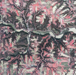
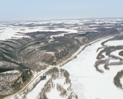
If Iowa’s landscape had to be divided into only two regions, one would be northeastern Iowa, and the other would include everything else. The rugged, deeply carved terrain seen in the Paleozoic Plateau is so unlike the remainder of the state that the contrast is unmistakable, even to a casual observer.
The most striking differences include abundant rock outcroppings, a near absence of glacial deposits, many deep, narrow valleys containing cool, fast-flowing streams, and more woodlands. This spectacular high-relief landscape is the result of erosion through rock strata of Paleozoic age. The bedrock-dominated terrain shelters unusually diverse flora and fauna , including some species normally found in cooler, more northern climates. Samuel Calvin, one of Iowa’s best known nineteenth-century geologists, spoke of these unexpectedly scenic landscapes as the “Switzerland of Iowa.”
The key to this refreshing difference in appearance is the widespread occurrence of shallow Paleozoic-age sedimentary bedrock. In no other region of the state is bedrock in such complete control of the shape of the land surface. The Paleozoic strata include fossiliferous rocks of Cambrian, Ordovician, Silurian, and Devonian age which originated as sediments accumulating on sea floors and along coastal margins of tropical marine environments that existed here between 300 and 550 million years ago. In the course of geologic time, these deposits hardened into brittle rock strata which were later deformed and fractured by crustal movements within the Earth. A widespread series of vertical cracks now extend through these rocks; some of these weakened planes are parallel to each other, others are oriented at nearly right angles. These features, called joints, are responsible for the blocky shapes and sheer faces commonly seen along rock bluffs and roadcuts. Their location also controls the abrupt turns noticed along many stream courses and valley segments throughout the region.
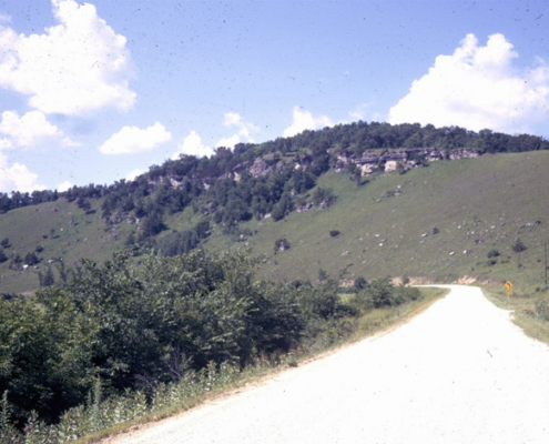
The entire sequence of Paleozoic rocks tilts gently toward the southwest, extending into deep basins in Kansas and Oklahoma. Ancient erosional processes in Iowa, including the work of Pre-Illinoian glaciers, beveled these inclined layers so that progressively older bedrock units appear at the land surface toward the northeast corner of the state. These sedimentary rocks are composed of limestone, dolomite, sandstone, and shale which vary in their resistance to erosion. Durable limestone, dolomite, and sandstone formations stand out as cliffs, pinnacles, ledges, and bluffs high on the landscape or as waterfalls and rapids breaking the stream flow along valley floors.
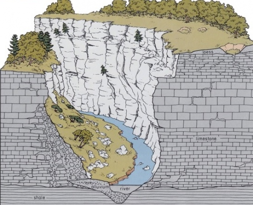
Shale, a less resistant rock, usually produces smoother, more regular landscape slopes. The different erosional characteristics of various strata result in terrain that mirrors the composition of the bedrock sequence so closely it is often possible to trace distinct geologic formations across the landscape. Broad, sweeping views of uniformly rolling summits often appear connected to lower but similar levels or to valley floodplains by steep escarpments. It is these different landscape levels that produce the angular stepped skyline and the distinctive plateaus in this part of Iowa.
The most easily observed Paleozoic strata protrude along the prominent winding line of wooded bluffs marking the Silurian Escarpment. This high, steep, nearly continuous rim of east-to-northeast-facing rock follows an irregular line from central Fayette County to southeastern Jackson County, where the sudden drop in the landscape also defines the western and southern borders of the Paleozoic Plateau. The plunge from the gently rolling Iowan Surface into the deeply carved, high-relief landscapes of the Paleozoic Plateau is clearly seen along the northwest-to-southeast line connecting West Union, Fayette, Strawberry Point, Edgewood, Colesburg, and Peosta.
This bluffline is interrupted by numerous small, narrow gorges and steep ravines which cause abrupt local changes in the direction of exposure. These various slope positions provide abundant havens of cool, moist, wooded habitats rich in diverse and sometimes rare communities of plants and animals. A noticeable concentration of protected natural areas in Iowa occurs along this prominent physiographic feature, including Brush Creek Canyon, Mossy Glen, Bixby, and White Pine Hollow state preserves.
The Silurian Escarpment is actually the leading up-dip edge (cuesta) of the massive slabs of Silurian-age dolomite and limestone that slope gently back to the southwest across Iowa. These strata form the uppermost bedrock across an area at least the width of a county before they are overtaken on the west by younger layers of Devonian limestones. Before the Mississippi Valley came into existence, Silurian strata also continued to the east. Today, however, only flattopped remnants of these rocks, termed outliers, are seen capping steep, isolated hills. Sherrill Mound in Dubuque County is a good example of an erosional outlier that is still close to the escarpment. Sinsinewa Mound located in southwestern Wisconsin and Scales Mound in northwestern Illinois are other Silurian outliers visible on a clear day from high elevations in northeastern Iowa, especially Balltown Ridge in Clayton County. The Silurian Escarpment returns again in northwestern Illinois, then snakes northward to rim the western and northern shores of Lake Michigan, the northern shore of Lake Huron, and the southern shore of Lake Ontario, reemerging spectacularly as the resistant limestone ledge that forms Ni agara Falls at the eastern end of Lake Erie. The prominent bulge in Iowa’s eastern border begins where Silurian rocks cross into Illinois at Dubuque County. This eastward deflection of the Mississippi River further demonstrates the resistance of these rocks to erosion.
Immediately below the Silurian rocks defending the escarpment in Iowa are more gentle slopes developed on older, soft, greenish gray Ordovician shale (Maquoketa Formation). This change marks a significant geologic boundary between Silurian and Ordovician time periods and between contrasting rock types of dolomite and shale. The zone of contact is often observed as a sharp break in topography from nearly vertical slopes to more gently inclined hillsides. The change in slope gradient also is often recognized by a noticeable change in land-use patterns from timbered Silurian slopes to pasture or row crops on the Ordovician. Seeps and springs are common features along valley sides that intersect the geologic contact between the highly permeable dolomite and the less permeable shale beneath. Additionally, angular slump blocks of dolomite, pitted and gray from long exposure to the weather, are often seen in tilted positions on the lower pastured slopes of shale where they have slid from their original outcrops. Balltown Ridge and county road X-71 northeast of Luxemburg in Dubuque County, Chicken Ridge in Clayton County, and Goeken Park (capped with Devonian rocks) overlooking the town of Eldorado in Fayette County are excellent places to observe some of these bedrock relationships and the very scenic landscapes they produce.
Continuing northeast from the Silurian Escarpment and underlying Ordovician shales are other plateau-like surfaces upheld by still older Ordovician limestone and dolomite strata (the durable Galena and Prairie du Chien groups). These rolling bedrock-controlled uplands also display massive escarpments that descend into or toward the great trench of the Mississippi Valley. The precipice where the Galena Group dolomites drop directly into the Mississippi Valley is especially picturesque at the Mines of Spain south of Dubuque, at the scenic overlook along U.S. 52 south of Guttenberg, and at Pikes Peak State Park south of McGregor. Mount Hosmer at Lansing and Blackhawk Bluff south of New Albin are other escarpments formed by still older Cambrian sandstone (Jordan Formation). Another scenic area where we can observe the effects of different bedrock formations on the landscape is found along the ridge-crest roads that radiate north and east from the Allamakee County highlands in the vicinity of Waukon. These vantage points overlook rolling landscapes with descending escarpments or steps formed by successively older outcrops of Ordovician dolomites (Galena), sandstone (St. Peter), older dolomites (Prairie du Chien), and eventually Cambrian sandstone (Jordan).
The limestones and dolomites that dominate so many of the Paleozoic Plateau landscapes are carbonate rocks. These lime-rich strata are slowly soluble in groundwater percolating through them from the land surface. The result of this dissolving action is the gradual enlargement of cracks, crevices, and other zones of weakness into caves and cavern systems. When these underground passages extend too close to the land surface, thin bridges of soil and rock collapse to form sinkholes. Concentrations of sinkholes can be seen in many parts of the region, including the vicinity of Iowa 9 in western Allamakee County and the area east of U.S. 52 in southern Clayton County. Even streams are occasionally swallowed by sinkholes in channel floors; this disappearance of flow can leave blunt-ended or abandoned valleys on the land surface.
Springs are another sign of subterranean drainage systems. Abundant in this region of Iowa, they usually are found along steep valley sides where erosional deepening has intercepted the flow of groundwater. Even during long periods without rain, streams in this region continue to flow because of the significant contribution of groundwater from bedrock aquifers. Dunnings Spring and Twin Springs, municipal parks in Decorah, and Cold Water Spring State Preserve in Winneshiek County are picturesque examples of these intriguing geologic and hydrologic phenomena. Cold Water Spring is the outlet of underground flow from one of Iowa’s largest cavern systems, Cold Water Cave.
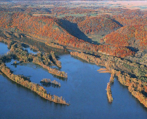
In addition to the strong visual impact of various types of bedrock and karst features on the landscape, one other obvious factor distinguishes the Paleozoic Plateau landscapes-the character of its river valleys. The region’s largest valley, the gorge of the Mississippi, is one of the most prominent physiographic features in the central United States. Tributaries that spill eastward into the Mississippi Valley over steep gradients through the Paleozoic Plateau include the Upper Iowa, Yellow, Turkey, and Volga rivers. The river valleys are deep, narrow, steepsided corridors carved into bedrock, often in surprisingly tight meander patterns. Such entrenched valleys usually display strong bedrock control of their courses, including abrupt, sharp-angled turns that trace the embedded fracture patterns described earlier.
As these river valleys evolved, some of their meander loops were abandoned, leaving horseshoe-shaped segments of old valley floors perched above existing floodplains. The abandoned meanders often partially surround steep, isolated rock cores. Sand Cove, standing more than 100 feet above the present floodplain along the south side of the Upper Iowa Valley in Allamakee County, is an excellent example. ‘The Elephant” and Mount Hope, nearby along the north side of the Upper Iowa Valley, are examples of large rock cores positioned on the inside bends of abandoned valley segments.
Another impressive abandoned valley slices through the landscape just north of Dubuque. This abandoned channel, known as Couler Valley, once carried the ancestral flow of the Little Maquoketa River to its junction with the Mississippi Valley near the present site of downtown Dubuque. The thin, steep divide near Sageville that separated their valleys was breached, and the Little Maquoketa waters were captured and permanently diverted along the shorter, more direct route straight east through Peru Bottoms. Horseshoe Bluff at the Mines of Spain also separates an ancestral valley of Granger Creek and Catfish Creek from the Mississippi. These scenic, abandoned valley segments and abandoned rock-cored meanders are a fascinating aspect of valley evolution in the Paleozoic Plateau.
Another component of northeastern Iowa valleys are the thick alluvial deposits within them. In the case of the upper Mississippi, large meltwater floods during the waning phases of the Wisconsinan scoured the valley, removing or rearranging earlier records. Side valleys now store the geologic ledgers registering earlier fluctuations in river level and sediment load that occurred out in the master valley. The ledgers exist in the form of alluvial terraces, those level but elevated remnants of older floodplain surfaces that flank valley margins. Clear Creek and Village Creek valleys west and southwest of Lansing contain well preserved terrace remnants as high as 60 feet above the present floodplains. Terraces are important in documenting the region’s complex alluvial history and the response of tributaries to changing water levels associated with glacial melting and drainage diversions in the Mississippi Valley.
For many years the eastern half of the Paleozoic Plateau was thought to be untouched by Pleistocene glacial activity and was referred to as the “Driftless Area,” which included similarly rugged landscapes in the adjacent parts of Illinois, Wisconsin, and Minnesota. This concept is no longer valid, however, as patchy remains of Pre-Illinoian glacial drift over 500,000 years old are documented on stream divides in the Iowa portion of this area. Pre-Illinoian drift is even more widespread in the western half of the Paleozoic Plateau, although it still plays no significant role in the present appearance of the region’s landscapes. Regardless of the relative amounts of glacial drift, the region stands united by the strong influence of bedrock geology, by a marked contrast to the remainder of the state where landscapes are subdued by glacial deposits, and by its many topographic and ecologic similarities.
Our understanding of Iowa’s glacial-age landscape evolution has grown significantly in recent years. As specific geographic areas and stratigraphic deposits have been examined in detail, we have seen an emerging unity among the state’s diverse landform regions. The Paleozoic Plateau, for all of its spectacular differences, fits neatly into the erosional history we have been compiling since looking at the Southern Iowa Drift Plain. Though the sedimentary rocks of this northeast Iowa landscape are ancient in comparison to all other landscape-forming materials in Iowa, the “preglacial” antiquity previously assigned to the landscape features themselves is being challenged. Recent investigations suggest that much of this rugged terrain is actually quite young. Stream erosion and hillslope development since Pre-Illinoian glacial events have produced the deeply dissected landscape and in the process have removed the glacial deposits from all but isolated upland positions. The same episodes of erosion reflected in the changing hillslope gradients of the Southern Iowa Drift Plain and in the scoured Iowan Surface and Northwest Iowa Plains also had a significant impact on the Paleozoic Plateau. The effects, however, are magnified by the bedrock-controlled relief and complicated by the steep slopes. The isolated distribution of Pre-Illinoian glacial deposits found on stream divides high in the landscape shows that the Mississippi River evolved during the early to mid-Pleistocene. The river’s network of tributaries in Iowa became established after the last Pre-Illinoian glacial events in the region 500,000 years ago. Loess-mantled, rust-colored Late-Sangamon paleosols are found on these remnant glacial deposits, and in places they extend onto the bedrock surface in the form of waxy red clays. At other locations loess lies directly on bedrock without any hint of a paleosol, conditions typical of the Wisconsinan-age Iowan Surface. These relationships confirm that multiple erosional episodes have cut across the entire Paleozoic Plateau.
Karst conditions develop at or just above the zone of groundwater saturation. Caves and passageways thus are strongly linked in time to periods when stream downcutting lowers the water table in shallow carbonate bedrock. The speleothems (stalactites, stalagmites, and flowstone) that decorate cavern systems cannot form until the karst openings fill with air and are largely free of groundwater. Uranium-thorium series radiometric dating of speleothems in Iowa and Minnesota indicate that major valleys were carved deeply enough into the landscape to bring the water table down and foster a major period of speleothem growth between about 100,000 and 160,000 years ago.
Most of the deep entrenchment of the region’s valleys, as well as formation of the prominent rock-cored meanders, occurred during the Wisconsinan, before 30,000 years ago. The ancestral valley meanders filled with stream deposits and were abandoned between 30,000 and 20,000 years ago. Intense frost action, producing unstable slopes and massive mechanical weathering and erosion, was brought on by the severe cold of glacial climates about 21 ,000 to 16,500 years ago. Locally, these periglacial conditions produced massive colluvial slopes of angular, blocky rock fragments (talus) along the sides of entrenched valleys. Karst conduits near the land surface also collapsed into large, blocky talus. The small, narrow gorges, described earlier emerging from the Silurian Escarpment, often mark collapsed sections of former cavern systems that were exhumed by the intense late-Wisconsinan erosional episode.
From about 18,000 to 9,500 years ago, the waning Wisconsinan ice front fluctuated on either side of the continental divide in Minnesota, separating drainage to the Mississippi from that to Hudson Bay. Catastrophic meltwater floods periodically surged down through the Mississippi Valley. Left behind are the series of elevated terrace deposits mentioned earlier, composed of silts and clays deposited in the slack backwaters of the Mississippi’s tributaries. For the most part, slower-paced sedimentation, minor downcutting, and lateral migration of river channels have been the dominant activities in the region’s valleys since then. It is important to realize that the progression of deposits from these floodplains and terraces up to the steep colluvial slopes, to the filled and abandoned meanders, to the ornamentation in caves, and to the rusty red, clay-rich upland paleosols are important linkages in time that verify the surprising geologic youthfulness of these rugged landscapes, even though they are developed on ancient Paleozoic bedrock. The deposits also have important geographic links, demonstrating that many of this region’s significant features were affected by the deepening presence of the Mississippi Valley.
Quarries are common in the limestone and dolomite deposits throughout the Paleozoic Plateau. The easily accessible bedrock is used for road construction and maintenance, though some is quarried for building stone. Bedrock deposits of the region also have a colorful mining history. Lead (galena) ore was mined for at least 300 years from veins occurring along crevices in the Ordovician (Galena Group) dolomites exposed along the Mississippi Valley and its tributaries. The hills around Dubuque are honeycombed with shafts and adits of this lead-mining activity. Even iron ore was mined in the 1890’s from a small, unusual occurrence of Cretaceous rocks found northeast of Waukon. This area, known as Iron Hill, is one of the highest points of land (1 ,345 feet) along this segment of the upper Mississippi Valley.
In addition to the economic value of the bedrock materials, many water wells have been drilled into the shallow creviced limestones and porous sandstones for drinking water. The karst characteristics of the area are a vivid reminder that contaminants from the land surface have direct access to these groundwater zones. In this vulnerable geologic setting, care must be taken to manage waste disposal and land-applied farm chemicals to prevent pollution of underground aquifers. Widespread contamination of the region’s shallow aquifers by nitrate and bacteria already has caused many wells to be abandoned and new wells to be drilled to deeper groundwater sources.
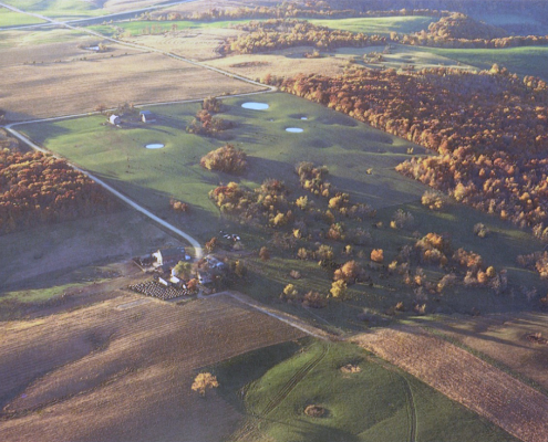
The Paleozoic Plateau also contains a large share of the state’s native woodlands. The steep, rocky slopes are unsuited to cultivation and remain forested. Some of this timber cover actually has developed since the time of Euro-American settlement when naturally occurring fires were suppressed. Along steep, dry slopes above major valleys, remnant prairies called goat prairies often can be spotted among the forested slopes.
With cropland at a premium in many areas, the small but productive floodplains and terraces along valleys are usually farmed. Areas of level uplands are also cultivated or used as pasture, especially for dairy cattle. The rugged topography lends itself to many types of outdoor recreation in both winter and summer. Those fishing for trout seek the deep, quiet pools below rocky riffles along the numerous spring-fed streams. Canoe enthusiasts can travel many miles of wooded and rock-bound waterways. Collectors can find abundant fossils in many of the exposed bedrock formations. The heavily timbered landscape supports a colorful autumn foliage, and the scenic region attracts many visitors each year.
Author: Jean C. Prior
Edited by: Drew Hutchinson

This information is based on the book Landforms of Iowa, by Jean C. Prior, published by the University of Iowa Press, Iowa City, in 1991. The book was designed and illustrated by Patricia J. Lohmann.