Photo courtesy of Iowa DNR
The northeast Iowa area around Pikes Peak State Park in Clayton County is one of the most beautiful and interesting regions of Iowa.
Its precipitous rock bluffs record a geologic history beginning over 500 million years ago. Various plant and animal communities have inhabited the region, shifting and evolving with climatic and cultural changes. The long history of its Native American residents is symbolized by the large number of mounds along ridge tops, many shaped as animal effigies. The arrival of Father Marquette and Louis Joliet in the region in 1673 opened a rich, new phase of regional history. French hunters, trappers, and miners were among the early historic residents. The region became a part of the United States with the purchase of the Louisiana territory in 1803, and was explored by Zebulon Pike shortly thereafter. Military forts were built, towns established, and roads constructed. In 1837, Alexander McGregor established a ferry across the Mississippi River. McGregor’s Landing was located at the site of the town that now bears his name. The Pikes Peak area was owned by McGregor, and, as a favorite family picnic spot, it was protected from being logged for firewood to feed the hungry riverboat boilers. Ownership of the area passed down through McGregor’s relatives, until it was given as a gift to the federal government. The property was later conveyed by Congress to the State of Iowa and became Pikes Peak and Point Ann state parks in 1935. Since settlers had never been allowed on the land, Pikes Peak today probably appears much as it did hundreds of years ago.
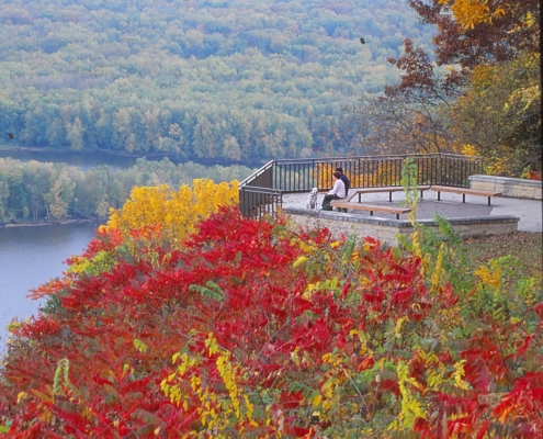
The highest bluffs at Pikes Peak are underlain by massive Paleozoic-age dolomites of the Galena Group. They provide panoramic views of the Mississippi River valley and its confluence with the Wisconsin River – the spot where French explorers Marquette and Joliet first saw the Upper Mississippi Valley in 1673.
An instructive and picturesque succession of geologic strata is wonderfully displayed within Pikes Peak State Park. The down-cutting of the Mississippi River valley has exposed a number of geologic formations in bold cliffs and steep ravines. The oldest rock formation exposed in the area is the Jordan Sandstone, which outcrops at Point Ann at the north end of the park. The sandstone, about 100 feet thick, was deposited during the latter part of the Cambrian Period, about 505 million years ago, as beach and near-shore sands of a slowly advancing and retreating sea. The Jordan Sandstone is an important aquifer, providing water to wells across much of eastern Iowa, including wells for drinking water at Pikes Peak.
Above the Jordan Sandstone is the Ordovician-age Prairie du Chien Group, named for the nearby city of Prairie du Chien, Wisconsin. These strata include a succession of dolomites with minor sandstone and shale, which reaches thicknesses up to 220 feet in the park. The erosionally resistant dolomite forms bluffs, exposed at Prairie du Chien and northward throughout much of the Upper Mississippi Valley to the Twin Cities. The dolomite layers were originally deposited as lime sediments in a shallow tropical sea that covered much of the interior of North America between about 490 and 505 million years ago. These sediments were subjected to later chemical replacement by dolomite.
The Prairie du Chien seas eventually withdrew from the interior of North America during later stages of the Early and Middle Ordovician, beginning a remarkably long period of erosion that continued for 25 million years. This erosional period was characterized by extensive weathering of the landscape, the cutting of deep river valleys, and the production of a network of caves and sinkholes, known to penetrate up to 350 feet deep in areas of eastern Iowa.
The Prairie du Chien seas eventually withdrew from the interior of North America during later stages of the Early and Middle Ordovician, beginning a remarkably long period of erosion that continued for 25 million years. This erosional period was characterized by extensive weathering of the landscape, the cutting of deep river valleys, and the production of a network of caves and sinkholes, known to penetrate up to 350 feet deep in areas of eastern Iowa.
As the seas again returned to the area, the deep valleys were filled with sand and shale, and a remarkably homogeneous interval of fine quartz sandstone was deposited across the region. This upper blanket of sandstone and the underlying valley-fill succession of variably colored sandstone and shale comprise the St. Peter Sandstone. The lower unit is of special interest in the area of Sand Cave in the park, where iron staining has produced rich colors, with reds, oranges, browns, and purples coursing through a mostly buff- to white-colored matrix of quartz sand.
Directly above the St. Peter Sandstone lies the gray-green Glenwood Shale. Only about four to five feet thick in the park, the shale is soft and easily erodible, so it is typically not well exposed in the park’s wooded ravines. The clay sediments that formed the Glenwood Shale were deposited very slowly in a shallow seaway, probably far from shore.
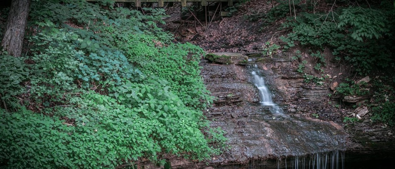
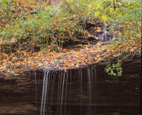
The Platteville Formation, a 45-foot-thick succession of limestone and dolomite strata, is exposed in the upper slopes in Pikes Peak State Park. It represents lithified sediments deposited in a broad tropical sea, which supported a diversity of shelled bottom-dwelling animals. The unit can be most easily viewed along the park’s boardwalk, where a small creek cascades over a resistant dolomite ledge to create Bridal Veil Falls.
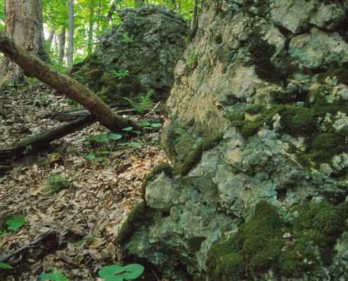
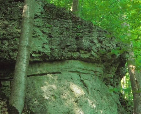
The uppermost rock interval exposed at Pikes Peak is the Galena Group, composed of the basal Decorah and the overlying Dunleith formations. The Decorah Formation is a succession of shale and limestone. The shales, typically greenish-gray in color, include spectacular lenses of brachiopod fossils. Interestingly, these shales also include thin but widespread layers of altered volcanic ash derived from distant eruptions near present-day Virginia. The clay shales and embedded ash deposits are soft and easily weathered, so they are not well exposed in the park.
Above the Decorah, however, the massive Dunleith Formation forms the highest cliffs and ledges within the park. These resistant dolomite and limestone beds are well displayed at the main Mississippi River scenic overlook and in old quarry workings within the park. The Dunleith contains almost no shale and is dominated by dolomite, which displays a considerable quantity of nodular chert (“flint”). This formation reaches thicknesses of 80 feet in the park and forms cliffs along the Mississippi River valley southward to the Dubuque area.
The modern Pikes Peak State Park landscape, dominated by steep bluffs, is the product of dramatic sculpting of the bedrock strata and deep incision by the Mississippi River. The floor of the Mississippi bedrock channel lies some 300 feet below the modern river level. This deeper level of down-cutting was likely related to episodes of continental glaciation during the last 2.5 million years, when vast ice sheets were present in the Northern Hemisphere, lowering global sea level up to 400 feet, and increasing the gradient of the Mississippi River. Then, as the ice sheets began to melt, huge volumes of meltwater and sediment moved down the Mississippi Valley and other drainageways scouring and deepening the valley. As sea levels progressively rose once again, the sediment-laden meltwaters deposited large volumes of sand and gravel within the valley.
Pikes Peak State Park, perched high on the bluffs overlooking the Mississippi River in Clayton County, offers an irresistible combination of natural beauty, colorful history, and informative geologic exposures. It rates as one of Iowa’s greatest natural treasures.
“Geology of Pikes Peak State Park,” by Brian Witzke and Ray Anderson, in Iowa Geology 2001, No. 26, p. 16-21.
Photos by Clay Smith, courtesy of Iowa DNR