Photo courtesy of Iowa Parklands
Within the quiet beauty of Springbrook State Park lie landscapes and geologic deposits that provide compelling testimony to the erosive power of rivers and their capacity to transport sediment over long distances.
River systems that once flowed here include a watershed that originated during the most recent glaciation of Iowa, and an older, larger drainage basin that included much of the eastern United States.
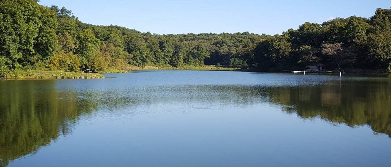
Springbrook Lake, covering 17 acres, was created in the 1930s by Civilian Conservation Corps workers who impounded the drainage of Kings Creek Watershed. The wooded hillslopes help prevent erosion and maintain water quality in this recreational lake.
Springbrook State Park, established in 1926, is situated just east of the Middle Raccoon River. The river’s course across Guthrie County marks the boundary between two strikingly different landform regions of Iowa — from the Des Moines Lobe to the northeast and the Southern Iowa Drift Plain to the southwest. Steeply rolling wooded slopes of the Southern Iowa Drift Plain are the product of extensive erosion of glacial materials deposited during several glacial episodes between 2.2 and 0.5 million years ago (Pre-Illinoian). To the northeast of the Middle Raccoon River lies more open, level agricultural land characteristic of terrain that was constructed by the most recent glaciation (Late-Wisconsinan). From the park’s scenic trails and shorelines, one can contemplate the cool moist presence of a low glacial ice front lying just east of the park 14,000 years ago.
Approximately 15,000 years ago, this glacier advanced into Iowa and left behind distinctive surficial deposits that are now referred to as the Des Moines Lobe. The Late-Wisconsinan ice sheet reached its southernmost extent, marked by the terminal Bemis Moraine, around 14,000 years ago. During this time, the Middle Raccoon River was diverted into an ice-marginal position along the advancing edge of the Des Moines Lobe. However, the immediate segment of river within the park itself diverges from the usual ice-marginal position and most likely existed in its present location prior to the ice advance.
The Des Moines Lobe glacier remained active in north central Iowa until approximately 12,000 years ago. This was 5,000 to 8,000 years later than the major Wisconsinan glacial activity northeast of Iowa, and well past the period of maximum glacial cold about 16,000 to 21,000 years ago. The Des Moines Lobe was actually a late surge of glacial ice that occurred during a period of already warming climatic conditions. The ice mass was probably relatively thin in Guthrie County, perhaps only a few hundred feet thick, and may have been even thinner along its outer margins. The ice surge, extending here to the edge of Springbrook State Park, likely was enhanced by lubricating melt waters that flowed at the base of the glacier. Fossil plant material collected from the Saylorville Reservoir area north of Des Moines indicates the presence of a spruce-larch forest in this general vicinity.
Additionally, in the Springbrook area, the glacier’s flow may have been compressed by a rising land surface beneath the ice. This causes shearing, thrusting, and deformation within the ice mass, which tends to mix materials and concentrate more porous sediment near the land surface.
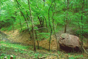
The narrow, steep-sided valley of the Middle Raccoon River was excavated relatively recently, approximately 14,000 to 13,000 years ago as the river carried greatly increased volumes of glacial meltwater from the Des Moines Lobe. Outwash gravels from this process are evident in gravel pits throughout the valley. They contain large boulders of glacially transported debris that were subsequently deposited by massive meltwater discharges. Within the park, these glacial boulders, composed of igneous and metamorphic rock from Canada and Minnesota, protrude from the valley floor of Springbrook Creek, a tributary to the Middle Raccoon River. These boulders lie in immediate juxtaposition with exposures of underlying river deposits of the Cretaceous-age Dakota Formation that outcrop in the valley wall — a compact and subtle indicator of a remarkable story of two river systems and two vastly different watershed environments contained within this single locale.
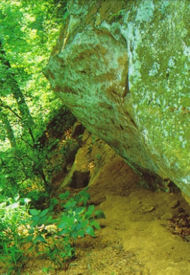
Steep valley sides along the Middle Raccoon River and its tributary streams cut into and expose these Cretaceous rock outcroppings. They consist of coarse-grained sandstones, pebbly conglomerates, and silty clay-rich mudrocks of the Cretaceous Dakota Formation, a rock unit present over much of western Iowa. These 100 million year-old sedimentary rocks were deposited by large westward-flowing rivers that built an aggrading alluvial plain, and, in the process, buried an older continental surface beneath hundreds of feet of river sediment. Quartz and chert gravel in the Dakota Formation conglomerates were eroded from eastern source areas located hundreds of miles upstream and were transported as coarse-grained river sediment into Guthrie County as part of a continental-scale watershed with headwaters in the western slopes of the Appalachian Mountains.

As seen in outcrops today, many of these rock types display crosscutting relationships that are characteristic of complex river channels. The large braided river systems ultimately drained into the Western Interior Seaway that was located hundreds of miles farther west in what are now central Kansas, Nebraska, and the Dakotas. The mouths of these rivers opened into expansive marine estuaries. Laminated mudstones, showing rhythmic tidal influences, from the head of one of these large bays were recently discovered just upstream from Springbrook State Park in the Middle Raccoon Valley.
Such discoveries provide new insights into the diverse depositional environments and watersheds that were once present in Guthrie County and also improve our regional understanding of the ancient geography of the mid-continent during Cretaceous time.
“Springbrook State Park: Watersheds Past and Present,” by Greg Ludvigson and Stephanie Tassier-Surine, in Iowa Geology, No. 25, 2000, p. 16-21.
Photos by Roger Hill and Iowa DNR