During the final months of 1990, midwestern attention focused on the “prediction” of a major earthquake along the New Madrid Fault Zone on Dec. 3. The date passed with considerable public attention and some anxiety but no earthquake. Questions remain, however, about when the next major New Madrid earthquake could occur, about the credibility of predictions, whether there is any danger in Iowa from earthquakes, and what preparations are appropriate.
Earthquakes occur primarily along fault zones, tears in the Earth’s crust, along which stresses build until one side of the fault slips, generating compressive and shear energy that produces the damage. The heaviest damage generally occurs nearest the epicenter, that point on the Earth’s surface directly above the point of fault movement. The composition of geologic materials between these points is a major factor in transmitting the energy to buildings and other structures on the Earth’s surface. Earthquake strength is recorded by a seismograph and is described using either the Richter Scale, which is a measure of the intensity of energy produced by an earthquake, or the Modified Mercalli Scale, which describes earthquake intensity by the damage that results.
While geologists often refer to the midwest as the “stable midcontinent,” because of its lack of major crustal movements, there are two regions of active seismicity, the Nemaha Ridge and the New Madrid Fault Zone. The Nemaha Ridge in Kansas and Nebraska, associated with the Humboldt Fault, is characterized by numerous small earthquakes that release stresses before they build to dangerous levels. The area is not considered a threat to Iowa.
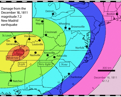
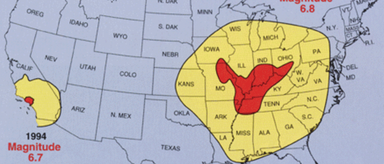
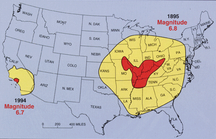
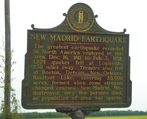
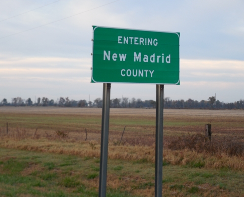
The New Madrid Fault Zone, on the other hand, has a greater destructive potential. It is located along the valley of the Mississippi River, from its confluence with the Ohio River southward, and includes portions of Illinois, Kentucky, Tennessee, Missouri, Arkansas, and Mississippi. The Earth’s crust in the midcontinent is older, and therefore thicker, cooler, and more brittle than that in California, for example. Consequently, earthquake shock waves travel faster and farther in the Midwest, making quakes here potentially more damaging than similar sized events in other geologic settings. The strongest historic earthquakes in North America occurred as a series of four shocks along the New Madrid Fault Zone between Dec. 16, 1811, and Feb. 7, 1812, and were centered near the town of New Madrid in the boot-heel area of Missouri. Based on historic eyewitness accounts, scientists have estimated the intensity of the earthquakes using the Modified Mercalli Scale and estimated an equivalent Richter magnitude of 8.3 to 8.7. These devastating earthquakes were felt from the Atlantic seaboard to the Rockies and felled trees, opened fissures, destroyed log buildings, erupted sand and water, created Reelfoot Lake in western Tennessee, and reportedly caused the Mississippi River to temporarily reverse flow in places. Because of the low population density, fatalities were relatively few, with most occurring on or near the Mississippi River.
Earthquake prediction is an inexact science. Even in areas that are well monitored with instruments, such as California’s San Andreas Fault Zone, earthquakes are only rarely predicted by scientists. As in the case of the Dec. 3, 1990, prognostication, there are always people who will profess some special knowledge of natural events that transcends traditional science and who will attract media attention. The public will do well to look at the credentials of those who make such dramatic statements and to seek authoritative sources for dependable information.
Seismologists attempt to forecast earthquake size and frequency based on data from previous events. In the New Madrid Fault Zone, this analysis is difficult because there are few historic moderate to large earthquakes, and the active faults are too deeply buried to monitor effectively. Based on recurrence intervals for small earthquakes, scientists estimated a 40 to 63 percent chance of a Richter magnitude 6.0 earthquake between 1985 and 2000, rising to a 90 percent chance by 2040. Estimated recurrence intervals for larger earthquakes, approaching the size of the 1811–12 events, vary from about 175 years to greater than 700 years. Will we get any warning prior to an earthquake? Maybe. Our understanding of earthquakes is increasing, and the future may bring a better forecasting system.
Estimated effects of a 6.5 Richter magnitude earthquake along the New Madrid Fault Zone suggest that Iowans in four southeast counties could experience trembling buildings, some broken dishes and cracked windows, movement and falling of small unstable objects, abrupt opening or closing of doors, and liquids spilling from open containers. About 29 other counties, from Page to Polk to Muscatine, could experience vibrations similar to the passing of a heavy truck, rattling of dishes and windows, creaking of walls, and swinging of suspended objects. These effects will vary considerably, with differences in local geology and construction techniques.
The effects in the Midwest of another severe earthquake like those of 1811–12 would constitute a major disaster. The New Madrid Fault Zone is now densely populated, with Memphis, Little Rock, Birmingham, Nashville, Louisville, and St. Louis all less than 250 miles from the most seismically active part of the area.
In Iowa, the direct physical effects would likely be minor to moderate, with structures built on poorly consolidated materials (such as river valley alluvium) nearest the epicenter suffering the heaviest damage. This could include fallen chimneys and cracked or broken walls and windows; disruption of local gas, water, sewer, and electric utilities; fluctuation of water levels in wells, springs, reservoirs, and streams; local landslides along steep slopes; liquefaction along floodplains; pressure changes in gas-storage facilities; and even land subsidence and sinkhole collapse. Additional consequences could include medical and other evacuations from damaged areas to facilities in Iowa, aid from Iowa sent to stricken areas, and increased east-west traffic through Iowa compensating for routes severed at the Mississippi River in the earthquake area.
Successful planning and mitigation efforts for earthquake events start with a knowledgeable public. Agencies such as the Federal Emergency Management Agency, the Central United States Earthquake Consortium, the Iowa Department of Homeland Security and Emergency Management, and local emergency response teams are all concerned with providing aid in the event of natural disasters. Experts stress that most efforts to protect lives and property during earthquakes work equally well for any disaster, and these basic measures are usually not expensive and take little time to implement. Anyone can and should obtain information ranging from where to take cover during an earthquake, to upgrading home utility connections, and preparing an emergency survival kit. Midwesterners are well aware of how to protect themselves during tornadoes. How well we respond to an earthquake at home, at work, at school, or traveling will depend on how well we understand the risks and how well we prepare.
By Raymond R. Anderson and Paul E. VanDorpe (Revised May 2020)
“Monitoring Iowa Earthquakes”: Iowa Geology, No. 6, 1981, p. 22–23
See “The New Madrid Earthquakes of 1811–1812” program by Ray Anderson