Elliot Anderson and Keith Schilling, Iowa Geological Survey, University of Iowa
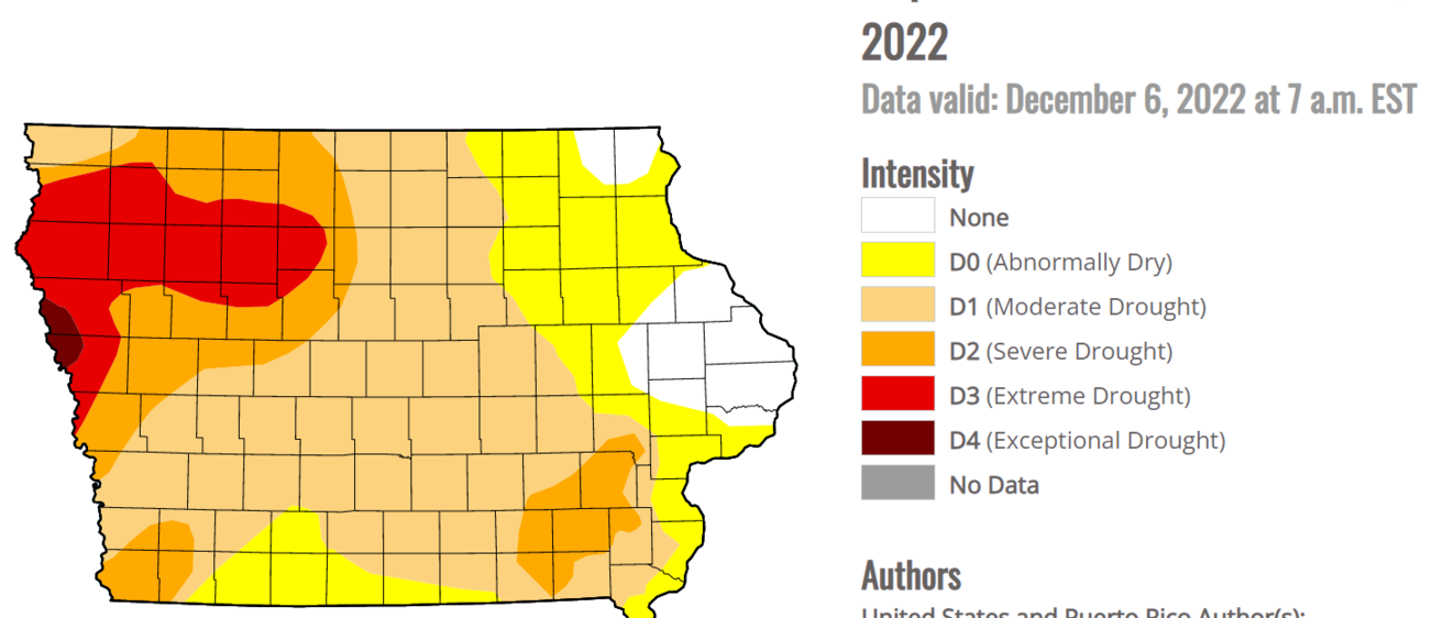
Several months of limited rainfall have once again made drought a pressing issue in Iowa. As of December 2022, over 90% of Iowa is experiencing some form of drought (Figure 1).
Northwest Iowa has been hit the hardest, with drought conditions in numerous counties being classified as Extreme or Exceptional. These conditions often have harsh consequences for Iowa stakeholders. Most notably, droughts reduce the agricultural crop yields commonly associated with Iowa, but water scarcity also impacts many other areas of life. Drinking water sources that rely on surface water from rivers or lakes incur new operational challenges involving water distribution and treatment. Groundwater supplies are also strained as reduced recharge depletes the available water volume in many shallow aquifers. Lower surface water levels can also hamper the economy, with navigation of Iowa’s waterbodies becoming more difficult and fewer opportunities for aquatic recreation. Additionally, droughts often raise ecological concerns, such as increasing fire risk and impairing surface water quality.
Unlike many natural disasters, drought is considered “slow-moving.” Whereas tornados, floods, or earthquakes can cause severe damage within a few days or hours, drought requires extended periods of dryness to materialize. One day without rain is unremarkable, but 100 consecutive rainless days in Iowa become very concerning. Due to this slow-moving behavior, drought description and detection remain active research areas worldwide. Iowa’s drought conditions are currently defined through the United States Drought Monitor (USDM) https://droughtmonitor.unl.edu/CurrentMap/StateDroughtMonitor.aspx?IA.
The USDM is housed at the University of Nebraska-Lincoln and represents a partnership between several federal scientific agencies. It processes regional hydrologic data, such as soil moisture, rainfall, and streamflow levels, to create drought classifications for the entire country.
While the USDM has long been a valuable tool for describing drought in Iowa, it has become increasingly recognized that additional guidance is needed to inform policymakers on how to proceed when drought is imminent. Many climatologists also worry that climate change will increase the prevalence of drought in the state, largely due to hotter temperatures and less consistent precipitation. Because of these concerns, a statewide drought plan is currently being developed via a collaboration between numerous Iowa agencies. A major goal of this drought plan is identifying trigger levels across that state that define drought severity and provide guidance to decision-makers. The plan will ultimately instruct officials on specific water-related precautions to take, including when and where water should be rationed.
The Iowa Geological Survey (IGS) has significantly assisted in creating the drought plan by providing scientific expertise on the state’s regional characteristics and available hydrologic data. One of IGS’s most important contributions was defining several drought regions across the state (Figure 2).
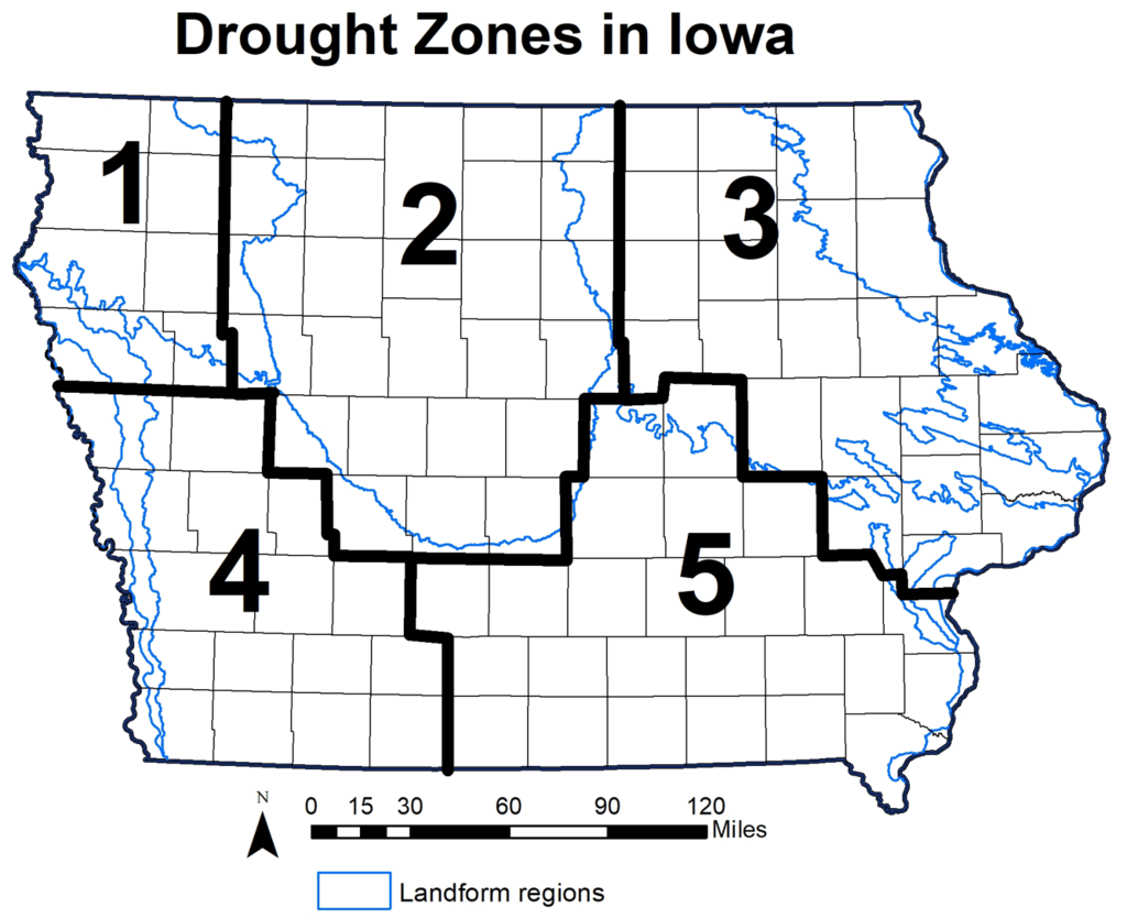
These five drought regions break Iowa into localized areas with similar hydrologic and geologic conditions. The hydrology and geology vary extensively throughout Iowa, so solely identifying drought at a statewide level can lead to many inaccuracies at a local scale. Dividing the state in this manner allows for describing drought at a higher resolution, where hydrologic behavior can be placed in its proper historical context.
The drought regions were partially based on landform regions delineated in 1991 by Jean Prior (Figure 3).
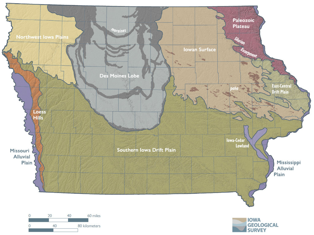
These landform regions reflect the diverse geologic landscapes shaped by glacial sediment and post-glacial erosion over the past two million years. The landform regions have similar landscapes, soils, geology, and hydrology, making them ideal for classifying drought regions. These five regions have been altered slightly to align with Iowa’s county boundaries. The landform regions are highly irregular shapes, so tweaking their boundaries to match those of the counties will greatly help with the drought plan administration. A full table of the drought region for Iowa’s 99 counties is provided here (https://iowageologicalsurvey.org/wp-content/uploads/2022/12/DroughtRegionCounties.xlsx)
Drought Region 1 contains eight counties in northwest Iowa in an area corresponding to the Northwest Iowa Plains. The rolling landscape consists of wind-blown silt (loess) above fine-textured glacial till. This is the driest region of Iowa, and the intense agriculture here relies heavily on groundwater obtained from shallow aquifers or deeper bedrock for irrigation, livestock watering, and municipal and private water supplies. This region is more vulnerable to water shortages during drought due to its reliance on shallow groundwater.
Drought Region 2 contains 26 counties within the Des Moines Lobe area, a landscape where glaciation occurred more recently. It consists of mostly flat, poorly drained plains marked by many small depressional areas and wetlands. The primary soils consist of silty and loamy materials formed in glacial till and wetlands. The region’s poor drainage and higher water table necessitated the building of numerous artificial drainage systems made up of subsurface tiles and ditches used to improve local crop production. The region is currently dominated by corn and soybean production, with the area being one of the most productive crop-growing locations in the world. This intense cropping is especially vulnerable to droughts due to their negative impacts on yields. Additional groundwater resources are available from bedrock aquifers and shallow aquifers.
Two landform regions in northeast Iowa, the Iowan Surface and Paleozoic Plateau, were combined to form Drought Region 3. These 24 counties consist of shallow sedimentary bedrock (primarily limestone, dolomite, and shale) overlain by fine-textured to coarse, sandy soils. Many areas of shallow limestone bedrock are characterized by numerous caves, springs, and sinkholes. Drought Region 3 is richer in water resources with many options for groundwater sources, including layered bedrock aquifers and alluvium along the major rivers. Drought impacts in this region are less dire than in other areas because of these resources.
Drought Region 4 consists of 16 counties in southwest Iowa, where thick deposits of silt (loess) form steeply sloping hills and narrow valleys. The loess thins in thickness from over 100 feet along the Missouri River border to tens of feet in the eastern counties. The loess overlies fine-textured and dense glacial till. Bedrock groundwater resources are extremely poor and are characterized by highly mineralized and poor-yielding shales, limestone, and sandstone. Deeper bedrock also contains poor water quality. The region’s principal aquifers consist of shallow sand and gravel deposits along major rivers, and these units are particularly susceptible to drought. Many public and private water users rely on Rural Water Districts that distribute water from centralized sources collected from lakes or well fields.
Drought Region 5 contains 25 counties in southeast Iowa, and it is similar to Region 4. The shallow geology consists of loess over glacial till except that the loess thickness thins substantially to the state’s eastern border. Rolling hills and a well-developed drainage system characterize the area. Water resources are poor in the south-central portion of the region but improve somewhat to the east, where shallow carbonate rock and deeply buried rocks are used for water supply. Many communities rely on shallow aquifers or surface water obtained from rivers or impoundments for their needs. This region’s public and private water users also rely heavily on Rural Water Districts.
IGS will continue to be involved in efforts with Iowa’s forthcoming drought plan, with drought classification schemes applied in each of the five regions. Future work will include developing a methodology for using streamflow to identify drought and operating a public-facing drought information system. Drought mitigation will likely remain a vital area of focus in the coming years, and IGS has a big part to play in identifying droughts to aid Iowa’s citizens.