Keith Schilling, PhD, State Geologist and Director, Iowa Geological Survey
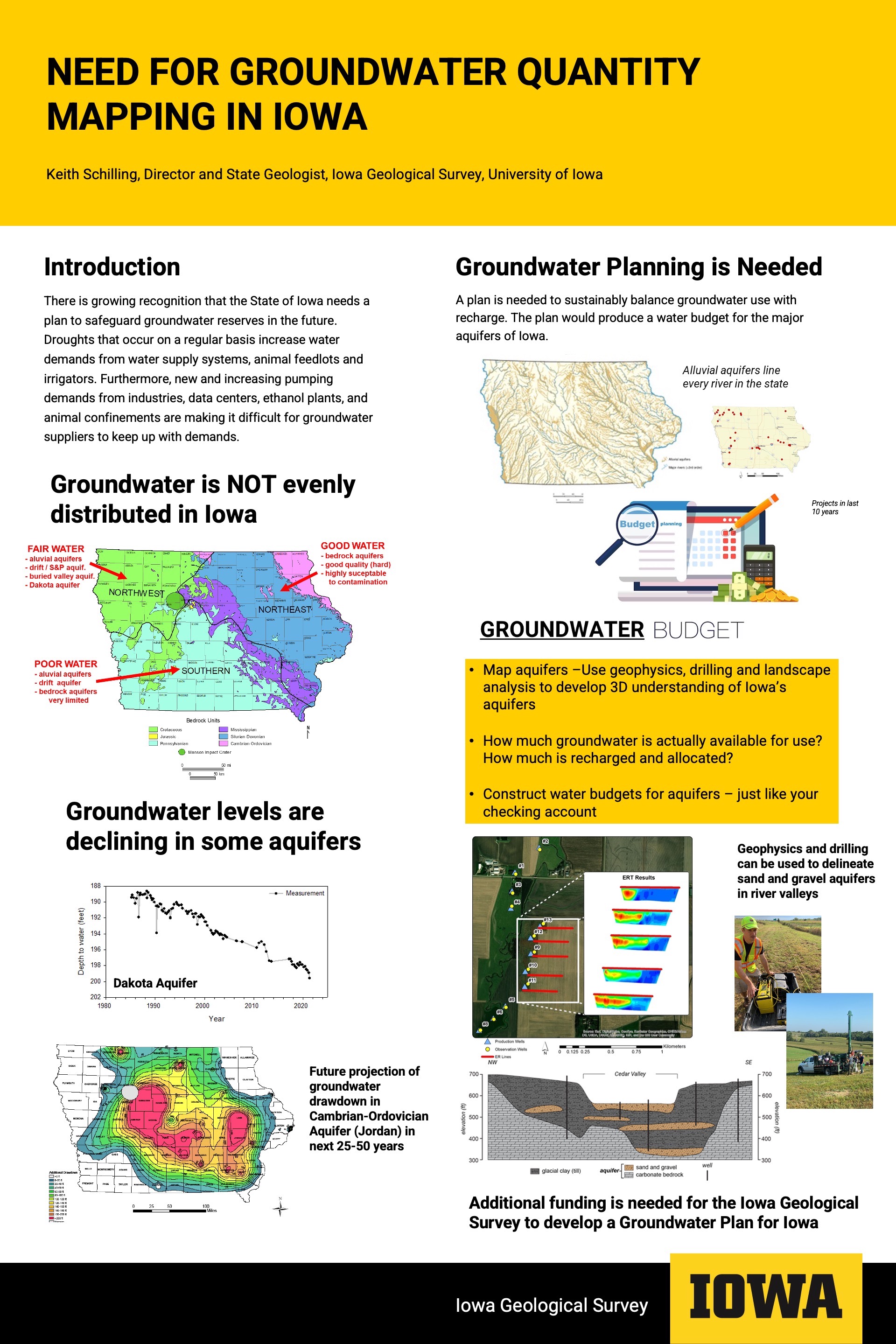
A conversion of several factors, some natural and some self-imposed, is leading to recognition that the State of Iowa needs a plan to safeguard groundwater reserves in the future. Droughts occur on average about once per decade in Iowa, and current drought was preceded by droughts in 2012, 2000, 1988-89 and beyond. Less rainfall during drought reduces infiltration recharge to shallow groundwater, lowers water table levels and reduces groundwater discharge as baseflow to rivers and streams. Drought conditions invariably increase the demands for agricultural crop irrigation, and many communities find that water use increases during drought from lawn watering and other outdoor water uses. In addition, new and increasing pumping demands from a rapidly urbanizing population, ethanol plants and other industrial facilities, data centers (requiring vast quantities of cooling water), animal confinements and other users are challenging urban and rural water systems to keep groundwater supplies on pace with demand.
Groundwater in Iowa is not evenly distributed, and there are water-rich and water poor areas of the state. Northeast Iowa is relatively groundwater rich because the bedrock aquifers in the area consisting of fractured carbonate rocks are able to store, transmit and yield large quantities of groundwater for use. Groundwater in this area is rapidly replenished with rainfall and snowmelt. On the other hand, western and southern Iowa are relatively groundwater poor, as the bedrock is either too fine-textured and impermeable to yield much water, or the aquifer is capped by hundreds of feet of clay-rich glacial soils that limit precipitation recharge. In these areas, water suppliers often focus on extracting groundwater from shallow sands and gravels that occupy rivers valleys (alluvial aquifers) or pumping from deep bedrock aquifers like the Cambrian-Ordovician aquifer (aka “Jordan” aquifer). Both of these aquifer types are vulnerable to drought and overuse. Water levels in shallow alluvial aquifers are rapidly lowered during drought when pumping continues as precipitation recharge stops. Water levels in deep bedrock aquifers decline because new and increasing demands exceed recharge.
A groundwater plan is needed for Iowans to sustainably balance groundwater use with recharge. Think of a groundwater supply like your checkbook at home. You get paid on a regular basis, and from this weekly “recharge” to your bank account, you pay your mortgage, bills, and occasionally go out to eat. It is important to have your checkbook balanced so that your expenses do not exceed your income and you fall into debt. The aquifers that contain our groundwater supply are similar to your checkbook. They receive recharge from precipitation or from leakage through other geologic units, they build up their water levels, and from this supply, we are able to withdrawl water from the aquifer “bank” to meet societal needs.
A groundwater plan would produce a water budget for the major aquifers of Iowa. The budget would tell us how much water is recharged to the aquifers, how much groundwater they contain, how much water is discharged to streams and leaked to lower aquifers, and how much water can be sustainably withdrawn without depleting them. For alluvial aquifers, creating a water budget would include mapping the horizontal and vertical extent of the sand and gravel deposits in the state. The Iowa Geological Survey (IGS) is well equipped to do this with geophysics, drilling and landscape analysis of glacial and post-glacial sedimentology. Although some mapping of alluvial deposits is done at local scales for water supply systems, there is a need to do this at a statewide basis where local interests can be put in the context of statewide needs. For example, local users of the Raccoon River alluvial groundwater rightly focus on their individual piece of the pie, but how much groundwater is available to everyone and how much can be sustainably pumped without depleting the resource and impacting flow to the Raccoon River? For bedrock aquifers where groundwater exploration can be expensive, groundwater budgets can be created using existing geospatial and rock core data available at IGS. Computer models of bedrock systems can then be developed to evaluate groundwater sustainability.
There is a need to for the State of Iowa to fund the research, mapping and analyses needed to improve our understanding of Iowa’s groundwater resources. A groundwater plan would balance the current and future needs for groundwater extraction with long-term sustainability for future generations.