Keith Schilling, State Geologist and Director
The retreat of the Wisconsin glacier approximately 12,000 years ago left behind a complex landscape of moraines, till plains, meltwater channels and outwash plains, including vast numbers of poorly drained topographic depressions termed prairie potholes. It has been estimated that 12.6 million pothole wetlands once covered the Prairie Pothole Region (PPR), but today, most have been drained for agricultural crop production. Where natural, water-filled potholes still exist, they play a critical role in local ecology and provide valuable habitat for migratory and wetland-dependent birds.
It is critical to evaluate and better understand hydrologic pathways within the PPR to assess risks to farmland and wetland sustainability from climate variations (droughts and floods) and contamination.
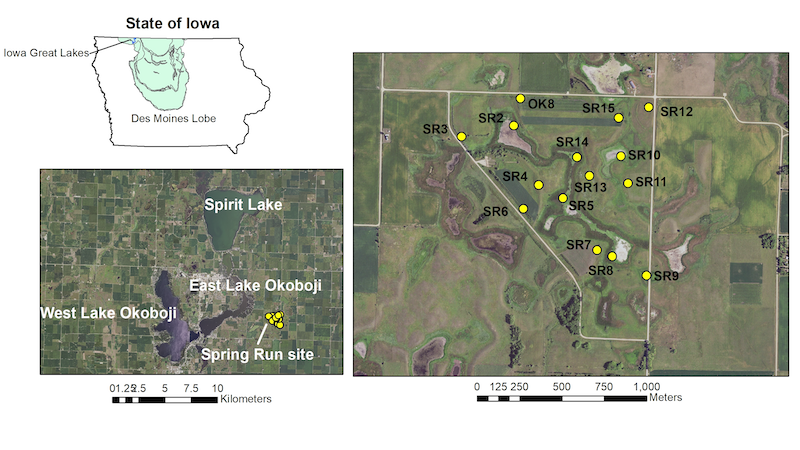
As part of a grant the Iowa Geological Survey received from the Iowa Department of Natural Resources Lake Restoration program for a diagnostic study of the Iowa Great Lakes (IGL) watershed, IGS researchers investigated groundwater flow patterns within the Spring Run pothole wetland complex located east of East Lake Okoboji. The small 130-ha Spring Run serves as a microcosm where local hydrogeology and groundwater flow pathways are representative of conditions found throughout the IGL. The location of Spring Run in the IGL region is shown here.

There is ongoing debate in the scientific literature about how groundwater moves through glaciated landscapes. In one camp, groundwater has been assumed to flow downgradient from higher recharge positions to lower discharge areas and wetlands are located where they intercept these regional flow paths. In the other camp, groundwater flow near potholes has been thought to be dominated by water table mounding and localized flow conditions. Resolving this question at Spring Run helps IGS assess and interpret groundwater flow patterns throughout the IGL region.
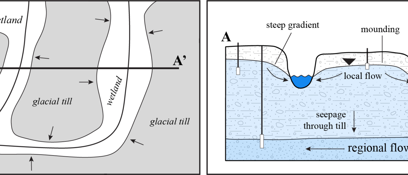
Over a two-year period (2022-2023), IGS evaluated the hydrogeology and groundwater flow system at the hummocky Spring Run wetland complex. Using a network of 16 shallow monitoring wells installed into upland glacial till and interspersed organic-rich wetlands, we found that groundwater flow within the upland till primarily follows local topography and discharges to local wetlands under steep hydraulic gradients at the till-wetland interface. The interspersed wetlands intercept the water table and provide areas for local groundwater discharge. Once groundwater flows into the wetlands, the wetlands direct water flow laterally out of the area or downward into regional sand aquifers. This simplified conceptual model highlights groundwater flow pathways at the Spring Run complex.

Unlike the first camp where it was assumed that wetlands intercept regional flow, we found no evidence that groundwater flow within one glacial till knob was hydrologically connected to groundwater flow in another. Overall, groundwater flow within a representative hummocky pothole complex at Spring Run appears to be highly localized. As work continues the IGL diagnostic study, efforts are underway to assess the groundwater contribution to the water and nutrient budgets of the entire lake system. Since natural shallow groundwater is localized within much of the region, regional transport of shallow groundwater and nutrients to the lakes may be primarily occurring in tile drainage systems and in deeper sand aquifers. Results from Spring Run study are helping IGS develop a better understanding of the hydrology present within the IGL watershed and the larger PPR region.
