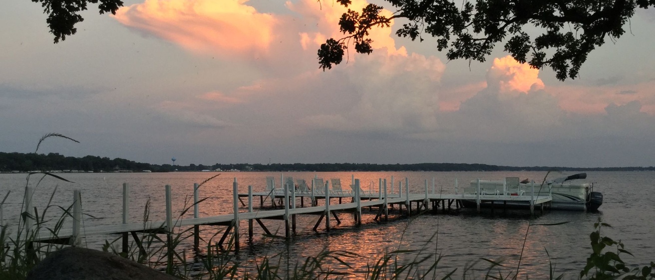
Researchers and area residents alike have puzzled over one aspect of West Okoboji Lake for decades: Why is the lake so deep?
The lake lies at the heart of the beautiful Iowa Great Lakes (IGL) region in northwest Iowa. West Okoboji Lake is the largest of eight natural lakes that create a home for fish and a magnet for fishing enthusiasts. Known to Iowans simply as “Okoboji,” the IGL region is a popular vacation destination and a huge economic driver for the area.

But for researchers at the Iowa Geological Survey (IGS) at the University of Iowa, the lake is also at the heart of a tantalizing geological mystery.
The answer lies in the region’s geology.
Water Quality Concerns
Keith Schilling, IGS director and Iowa state geologist, led a recent research project to better understand how water and nutrients enter the lake. Four IGS researchers — Thomas Doyle, Phillip Kerr, Schilling, and Matthew Streeter — collaborated on an effort to find the answers.
Funded by the Iowa Department of Natural Resources (IDNR) through its Lake Restoration Plan, the Iowa Great Lakes Hydrology and Diagnostic Study looked at groundwater and surface water’s movement throughout the watershed and their nitrate and phosphorus contributions to West Lake Okoboji.
Statewide, nitrate pollution in Iowa’s waterways stresses fish and disrupts their reproductive processes. The IDNR lists several bodies of water in the IGL region as impaired due to excess nitrate, which can trigger algae blooms that deplete oxygen in the water. In extreme cases, this can create “dead zones” where fish and other aquatic life can’t survive.
Concerns about water quality in the Iowa Great Lakes and its impact on the region’s economy was one of the primary drivers of the IGS research project.
“There’s a major interest in water quality in the great lakes,” Streeter says, “so we were actually trying to source those nutrients.”
Glacial Processes
To achieve their goals, the IGS team needed a foundational understanding of the glacial and geologic processes that shaped the landscape tens of thousands of years ago.
“The Iowa Great Lakes have always been kind of curious to me,” says IGS geologist Phil Kerr, who says he was excited to explore the geological mysteries of West Lake Okoboji.
The Iowa Great Lakes lie at the northwest edge of the Des Moines Lobe in north central Iowa, where the Wisconsin glacier plowed through the state some 17,000 years ago. When the glacier retreated, it left behind a hummocky landscape, with many small rounded knolls and kettle-like marshy depressions — and one very deep lake.
Why was West Lake Okoboji so much deeper than the others?
Kerr and Doyle used information on the landforms, subsurface, lakebed topography, and water well data from the IGS Rock Library to reconstruct the region’s glacial history.
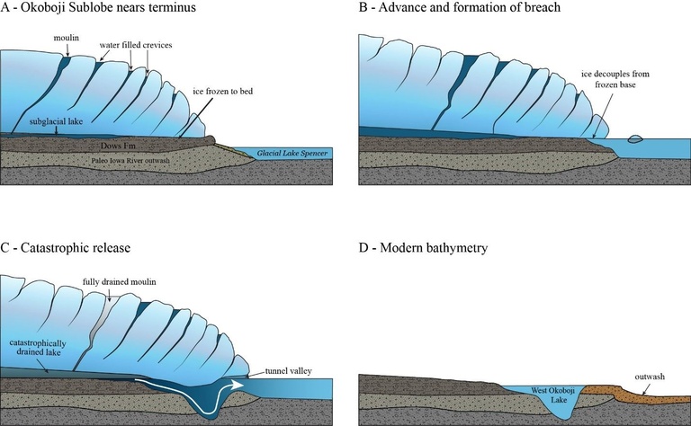
In the process, they made a big new discovery about the glacial history of the area — the glacier’s previously unknown Okoboji Sublobe, which moved south alongside and later atop the main Des Moines Lobe as it was beginning to collapse and disintegrate.
When the two glacial lobes collided, they buried vast chunks of ice. When the glacier retreated, a buried ice chunk and a catastrophic flood carved out a deep tunnel river valley that is now West Okoboji Lake.
Aha!
“I actually recall the first ‘eureka’ moment,” Kerr says.
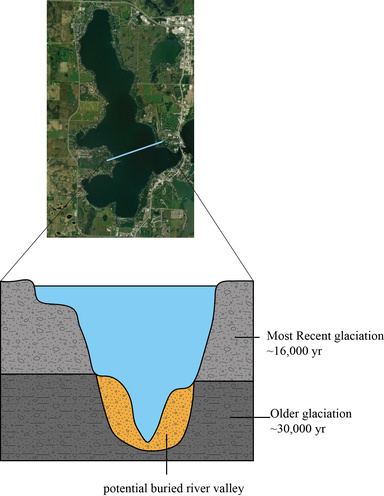
While sifting through the data, Doyle noticed a shelf jutting out on both sides of the very steep lakebed, before it plummeted again to the bottom. The shelf was at the same elevation as buried sand and gravel bodies north of the lake.
With mounting excitement, Kerr and Doyle realized that the shelf was the top of a sand and gravel body, part of a river valley that had been buried by the most recent glacier.
“It felt like finding a trailhead after wandering around in a forest,” Kerr says. “It was really fun to map this and to help tell that story really gives the context to how water can move throughout the system.”
He adds, “If we understand the overriding geologic story, we can better determine where groundwater is going and where it’s coming from.”
Water Sources
Armed with this new geological information, the researchers went to work to better understand how water and nutrient pollution are entering and moving through the watershed.
Streeter drilled 30 groundwater monitoring wells around the West Lake Okoboji area in farm fields, golf courses, and even under pavement in cities. The team also installed stream gauges and water quality monitoring sensors. With these data, they were able to model water and nutrient movement throughout the entire IGL watershed.

“What we learned was that groundwater tends to be pretty localized,” Schilling explains. “Most of that water in the glacial till discharges to the nearest wetland and leaves the system through evapotranspiration. That water never makes it to the Okoboji Lake.”
The lake’s source water is also quite different in a flood year vs. a drought year. “In a normal water year, you do have a vast majority coming from your surface water inputs — surface runoff from the small tributaries that are feeding the lakes,” Doyle says.
In dry years, that changes, and groundwater starts making up a larger part of water coming into the lakes.
Doyle adds, “This is a very seasonally-dependent, flashy system. Contributing flows vary drastically depending on the annual precipitation.”
Location, Location, Location

This enhanced understanding of water’s flow into the lake allows landowners and other stakeholders to make smart choices on where to locate wetlands and other water quality remediation solutions that can capture nitrate and phosphorus runoff before it reaches the lakes.
And these conservation practices are working.
“It was reassuring to see that in the watersheds that had something like a wetland near their outlet, you did see really significant nutrient loss between upstream and downstream of those practices,” Doyle says. Adding more wetlands to the landscape will further improve the quality of water flowing into the lake.
The project’s sponsors at the IDNR are pleased with the results. “This report perfectly bridges complex geological science with actionable environmental management. Partners in the region are already incorporating this report into our watershed management work,” says Michael Hawkins, regional supervisor of the IDNR’s Fisheries Bureau.
But there’s more work to do and more questions to answer. “This also kind of raised a lot of questions that we’d like to go back and answer in the future,” Doyle says. He and his colleagues want to know more about the deep sand body that interacts with West Okoboji Lake.
Streeter agrees. “We certainly have a lot of good resources at the Iowa Geological Survey, with our groundwater expertise, to look at lakes in different sizes and scales all over the state. … We could do it in a lot of places.”
It’s a partnership worth cultivating, Schilling says. “All these lakes have their own story. We would love to get involved in more lake projects like that.”