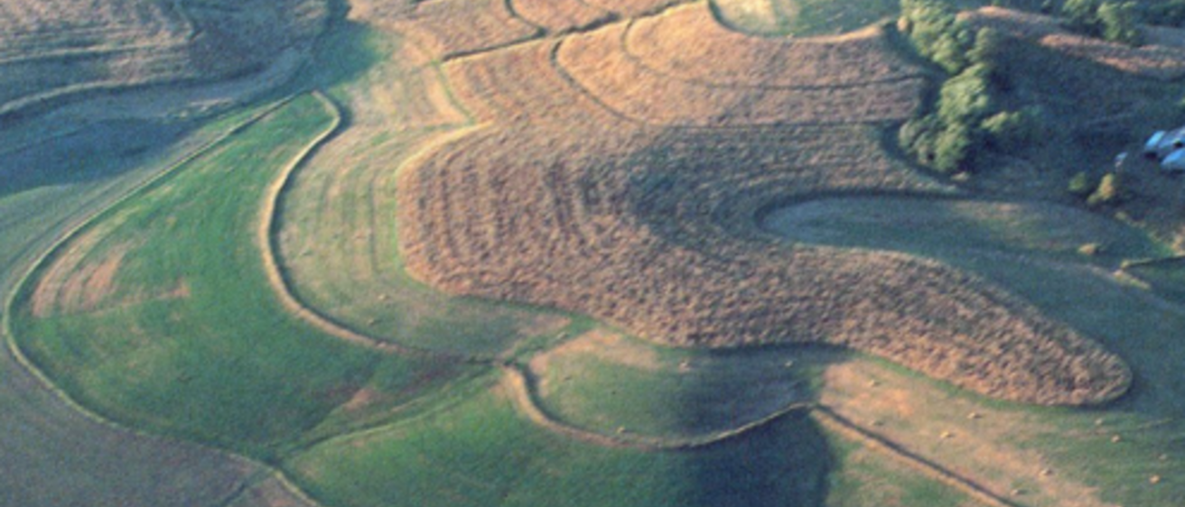
The topography of the Southern Iowa Drift Plain is perhaps most representative of “typical” Iowa landscapes.
The Southern Iowa Drift Plain is certainly the largest of Iowa’s landform regions and it is the primary region travelers on Interstate 80 will see. Noted Iowa artist Grant Wood emphasized the steeply rolling character of this landscape in many of his stylized paintings, especially Young Corn and Fall Plowing. The landforms of this region, like those of the Des Moines Lobe, are composed primarily of glacial drift, but the massive ice sheets that carried material into this part of Iowa were older by hundreds of thousands of years than those that occupied the north-central area of the state. It is this geological generation gap that makes all the difference in the appearance between these two regions.
Features typical of a freshly glaciated landscape have been obliterated by time. Gone are the moraines, kames, kettles, bogs, and lakes—all those distinctive visual clues to recent contact with glacial ice. The only remaining evidence to verify passage of these earlier ice sheets is the ten to hundreds of feet of glacial drift covering the bedrock surface. Instead of poorly drained, low-relief landscapes, streams have had time to establish well-connected drainage systems and to carve deeply into the land surface. Hillslopes, especially those higher in the drainage network, often display a texture of finely etched rills that give a distinct ribbed or furrowed appearance to the terrain. These rills give way to ravines, then to creeks that flow part of the year, and eventually to perennial streams and rivers in major valleys. Patterned like the branching veins in a leaf, this dendritic network has drained the postglacial wetlands, erased the ice-contact landforms, and over time has reshaped these old glacial plains into the deeply creased landscapes so familiar in this region today.
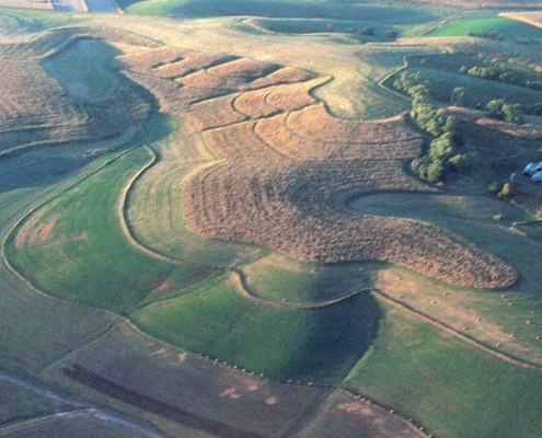
With most of the land surface sloping toward some drainageway, the terrain of this region projects a feeling of enclosure when we travel among its hills. Views extend only as far as the next rise or the next bend in the road. There are no long-distance vistas except those seen from hillcrests that return again and again to the same elevation, each time providing a glimpse over the billowy landscape beyond. At night, farmstead lights suddenly dot the darkness, or approaching headlights abruptly drop from sight as the road alternately rises and falls. The observation that Southern Iowa Drift Plain summits always seem to return to a uniform elevation is a clue to their geologic origins. These even-topped uplands disclose the approximate level of the original, once-continuous land surface constructed by the last ice sheet to pass this way. Every hillslope and valley floor mark the extent of erosion into the old glacial plain. The space between hills emphasizes the great amount of material that has been removed and the hundreds of thousands of years this process has taken.
The erosional processes that have carved these hills from the earlier glacial plain have not been at work continuously or uniformly through time. Instead, the past has been punctuated with episodes of rapid erosion accompanied by valley deepening and lengthening. The episodes of downcutting alternated with periods of greater landscape stability when soil profiles could weather deeply into the exposed glacial deposits. This variable intensity in the erosional shaping of the landscape actually left broad steps notched into the hillslopes of the region’s drainage basins. These stepped erosion surfaces occur throughout the portions of Iowa where Illinoian and Pre-Illinoian glacial deposits are the dominant landscape materials. Thus, hillsides are a key element of Southern Iowa Drift Plain landscapes. They may appear at first glance to be smoothly flowing slopes, but subtle changes of contour from more steep to less steep reveal past irregularities during their long erosional history.
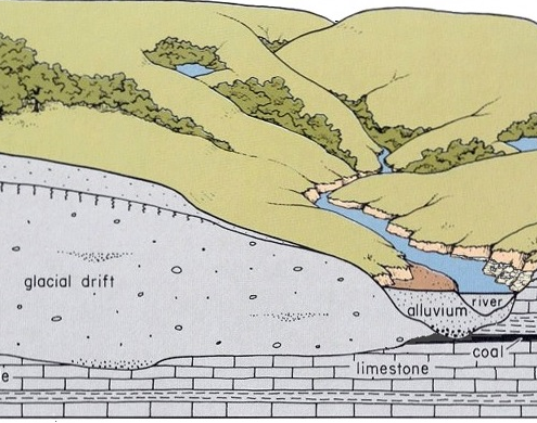
As this dissected landscape was evolving, a windblown mantle of loess was added to the land surface. This silty (and sometimes sandy) deposit usually ranges in thickness between 5 and 30 feet throughout the region and is deep enough in places to add to the local relief, particularly on leeward hillsides and along valley margins. The thickest loess deposits over the region are found close to major sources of windblown silt. Thick deposits also are preserved on broad, uneroded uplands where the most continuous accumulation occurred, while on narrower divides and hillslopes loess deposits generally are much thinner because of erosion. The bulk of this silt mantle is composed of Peoria Loess. Beneath this loess in the western part of the region is an additional thin wedge of the older Pisgah Formation loess, and below that the still older, widespread Loveland Loess occurs. These windblown deposits are thickest near the Missouri River valley and become thinner toward the central portion of the Southern Iowa Drift Plain. The Peoria Loess then thickens again nearer the Mississippi River and other eastern Iowa valley sources. As seen in the previous section, the influence of this windblown silt in extreme western Iowa dominates the appearance of an entire landform region.
Across the loess-mantled Southern Iowa Drift Plain, remnants of four major landscape levels are preserved. Some of these are prominent, platform-like features, while others are seen only as a gentle flattening of the gradient along a hillslope profile. The four landscape levels, or surfaces, were progressively eroded into the old glacial plain, leaving the oldest landscape surface at the highest elevation; the newer, younger surfaces each cut into lower landscape positions and into stratigraphically older material. The four surfaces (highest to lowest and oldest to youngest) are known as the Yarmouth-Sangamon, the Late-Sangamon, the Wisconsinan (Iowan Surface), and the Holocene (postglacial). These surfaces differ in age and in the thickness of their loess mantle. They also vary in their preservation and dominance in the landscape from one place to another. It is helpful to keep in mind that most of these Pleistocene surfaces originally developed on landscapes that are no longer part of the present land surface because they were buried by younger deposits or were pruned back by later episodes of erosion. As a result, today’s hillslopes are not underlain by uniform materials of the same age; instead, descending slopes cut across a series of paleo-landscapes and a sequence of different glacial-age strata. Because these Pleistocene materials are relatively soft, at least compared to bedrock, they leave smooth shapes in the landscape. There are few obvious, abrupt breaks in slope to highlight where these changing stratigraphic relationships occur; there are, however, some useful clues.
The highest and oldest landscapes in the region are flat-topped upland summits. These broad, loess-mantled uplands are largely uneroded remnants of the last Pre-Illinoian drift plain that lay exposed to weathering during the Yarmouth, Illinoian, and Sangamon stages. This Yarmouth-Sangamon surface has a distinct loess-mantled paleosol. Where it outcrops on hillsides beneath the loess, the paleosol is usually noticed as a thick, gummy gray clay. This ancient soil profile, once referred to as “gumbotil,” often has a pronounced effect on local drainage conditions because it acts as a barrier that retards the downward movement of groundwater. Rainfall and snowmelt percolating through the loess tend to move laterally once they reach the less permeable clay of this paleosol. Seeps or springs often develop on hillsides where the clay-rich zone is intercepted by the land surface. Such areas of “gumbo,” notoriously sticky when wet and rockhard when dry, are well known to farmers working the fields of this landform region.
Throughout the Southern Iowa Drift Plain, a gradual topographic shift occurs in the position and amount of level terrain from east to west. It is obvious in parts of southeast Iowa that extensive areas of nearly flat, uneroded uplands—the Yarmouth-Sangamon surfaces—are more common than the typical steeply rolling hills. In many locations, around Ottumwa, Fairfield, Mount Union, or Mediapolis, for example, these tablelands (tabular divides) are the strongest visual element of the landscape, and steep, hilly, wooded terrain occurs only near stream valleys. The amount of level land along valley floodplains is small in comparison with that on these extensive upland areas.
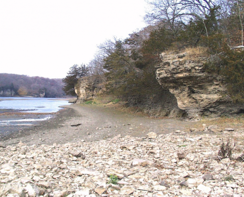
The presence of these undissected uplands in southeast Iowa seems to reflect the influence of shallow bedrock. Erosion of the glacial deposits, very common elsewhere in the region, has been slowed here because streams draining these uplands encounter more resistant Mississippian limestones and dolomites in their valleys and thus are inhibited from cutting deeper and farther back into the upland divides. Karst features, such as caves, springs, and sinkholes, which are abundant in northeast Iowa, are also seen in this region in the Burlington area where limestone occurs particularly close to the land surface.
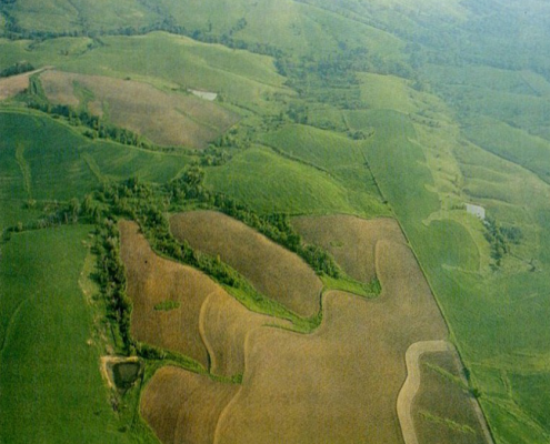
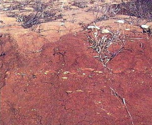
Below the high upland summits of the region, the younger Late-Sangamon surface is frequently seen as a gentle shelving or flattening of the gradient along hillslopes. From beneath its loess mantle, the thinner but distinct paleosol that marks this former land surface appears as a rust colored zone caused by oxidation of iron particles. This clayey paleosol is commonly seen streaking freshly plowed hillsides, particularly in the spring and fall when soil color is most easily noticed.
The terrain of south-central and east-central Iowa is more dissected, more deeply cut by streams. The nearly level upland divides, so prominent in southeastern Iowa, are much smaller in area, and most of the land surface is in hillslope; sightings of the Late-Sangamon paleosol are common. This topography is typical of an area that includes Monticello, Iowa City, Oskaloosa, Centerville, Chariton, and Indianola.
A still younger Wisconsinan erosional step can be observed crossing lower hillsides within the Southern Iowa Drift Plain. This narrow, subtle surface is distinguished by a very thin loess cover and the noticeable absence of any paleosol. The Wisconsinan erosion surface was cut into the landscape while loess was being deposited during the intense glacial cold that gripped the midcontinent between 16,500 and 21 ,000 years ago. The best topographic expression of this erosion surface is seen throughout the region mapped as the Iowan Surface, where it extends across virtually the entire landscape. In the Southern Iowa Drift Plain, however, its gentle incline occupies just the lower slopes of drainage basins. An interesting stratigraphic feature sometimes seen on both the Late-Sangamon surface and this younger Wisconsinan surface is a stone line or pebble band. This residual or lag deposit of glacial gravels was concentrated at the land surface over a period of time as erosion removed the surrounding finer materials.
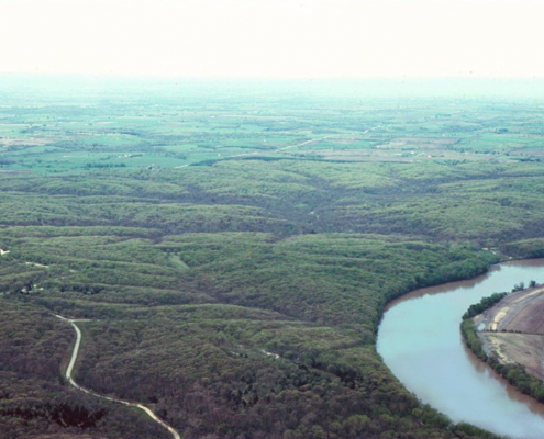
The topographic shift across the region continues into southwestern and western Iowa, where the flat upland summits disappear almost entirely. The hills here appear aligned in long, parallel crests of steep waves with broad troughs between them, as seen in the areas around Denison, Atlantic, Red Oak, and Creston. The most extensive areas of level terrain occur along valley floors. The floodplains here and elsewhere across the state thus mark the lowest and youngest (Holocene) erosion surface cut into the landscape. This surface is marked by postglacial alluvial deposits.
Throughout the Southern Iowa Drift Plain, the relative amounts of level upland divides, steeply rolling hillslopes, and lowland valley floors vary considerably. How-ever, the arrangement of these various landscape elements, the relief resulting from the combined episodes of erosional history, and the exposed paleosols that sometimes color the hillslopes are the dominant unifying characteristics of the region.
Investigations since the mid-1970s have substantially revised the stratigraphic subdivisions of the older glacial deposits that form the bulk of this region’s landscapes. Traditional glacial and interglacial terms such as “Kansan,” “Aftonian,” and “Nebraskan” have been abandoned. The concept of one till per glacial period, as interpreted from exposures of glacial deposits, did not hold together after core-drilling at many of the classic localities in western Iowa revealed as much as 200 feet of additional glacial deposits below some of the previously studied outcropping units. Geologists then recognized that the glacial sequence in Iowa is quite complicated, with more glaciations, at least seven more till sheets, and more buried soil profiles than were previously described. As a result, all Quaternary deposits older than Illinoian (greater than 300,000 years old) are, for now, referred to collectively as Pre-Illinoian.
The work in western Iowa was followed by detailed landscape analysis, outcrop descriptions, and drilling investigations over large areas of eastern Iowa. The fieldwork was combined with laboratory studies of various mineral grains within the Pre-Illinoian till deposits, as well as a re-evaluation of where and how many paleosols occurred. The various physical and mineralogical characteristics that emerged from these studies permit the division of Pre-Illinoian glacial deposits into distinct lithologic units named the Wolf Creek Formation and the older Alburnett Formation.
In addition to Pre-Illinoian glacial deposits, the Southern Iowa Drift Plain also includes the small area of eastern Iowa covered by Illinoian glaciation about 300,000 years ago. Only the oldest of several Illinoian glacial advances actually entered Iowa. This advance was part of an ice mass known as the Lake Michigan Lobe, which covered most of Illinois as it extended southwesterly from a larger continental ice sheet. The deposits that remain in Iowa from this eastern-source glacier are known as the Glasford Formation (Kellerville Till Member). They contain an abundance of Pennsylvanian rock fragments, including coal and plant fossils common to the bedrock of eastern and central Illinois. These materials contrast sharply with Iowa’s Pre-Illinoian till deposits, left by glaciers that crossed much different Tertiary, Cretaceous, and Precambrian rock types as they advanced along flow paths from the north through the Dakotas, Minnesota, and the Lake Superior area before pushing completely through Iowa into Missouri. In this area of Illinoian glaciation, however, as with the region as a whole, sufficient time has elapsed for erosion to reshape the glaciated terrain and establish an integrated drainage network, producing landscapes that resemble the rest of the Southern Iowa Drift Plain.
Further supporting the major revisions of Iowa’s early glacial record is the fascinating evidence provided by volcanic-ash deposits found sandwiched between some of the Pre-Illinoian glacial tills in western Iowa. These gritty, whitish gray deposits are windblown partides consisting of glass shards and pumice fragments. Their chemical and mineralogical composition can be traced to eruptions of now-extinct volcanoes in Yellowstone National Park in northwestern Wyoming, approximately 850 air miles west of Iowa. Preserved remnants of ash falls from these eruptions are known to occur in Woodbury, Guthrie, Adair, Union, Ringgold, Harrison, Monona, Audubon, and Cherokee counties. No deposits of volcanic ash have been found in the eastern part of the state.
Through a technique known as fission-track dating, four separate ash falls from the Yellowstone area have been dated in Iowa and Nebraska. They have ages of 0.6, 0.7, 1.2, and 2.2 million years and as a group are referred to as the Pearlette Family of volcanic ash deposits. The 2.2-million-year-old ash overlies the oldest of at least seven separate Pre-Illinoian glacial deposits recognized in Iowa. This pinpoints the beginning of glaciation here as sometime before 2.2 million years ago—considerably older than many previous estimates. This dating is important to establishing a time frame for Iowa’s glacial record and correlating glacial-age events here with those in other parts of the world.
The valleys eroded into these old glacial deposits are among the most picturesque features of the Southern Iowa Drift Plain. Many of the larger river valleys, especially the Cedar, Iowa, Skunk, Des Moines, Boyer, and Little Sioux, had glaciers standing in their headwaters during the time the Des Moines Lobe was ice-covered. These valleys obtained much of their present width, depth, and alluvial fill during meltwater flooding as the Wisconsinan ice sheet disappeared from north-central Iowa. In many places, the rivers have carved completely through the upland sequence of loess, paleosols, and glacial drift into the layers of sedimentary bedrock beneath. The rough, wooded terrain adjoining these deeper valleys supports many scenic recreation areas and important wildlife habitats. The dendritic patterns of streams established across the landscape result in mosaics of cropland, pasture, and timber. Contour plowing, stripcropping, and grass-backed terraces often are used to minimize soil erosion and conserve water on the cultivated hillsides.
In addition, the steeply rolling terrain is suited to building dams to form reservoirs. Three of Iowa’s largest reservoirs are in this region–Coralville, Red Rock, and Rathbun. These structures control flooding and also provide recreational opportunities and sources of water. The shorelines of these reservoirs are indented with numerous inlets marking the locations of smaller tributary valleys in the formerly well drained landscape.
Across large areas of the Southern Iowa Drift Plain, groundwater is not as plentiful as in other parts of the state. For example, the thick sequence of shale-dominated Pennsylvanian bedrock underlying central and southwestern Iowa is a notoriously poor source of groundwater for wells. Many rural residents in southern Iowa depend on large-diameter wells that tap shallow groundwater seeping along the contact between the loess and underlying, less permeable glacial till. Farm ponds are a characteristic feature of the steeply rolling landscapes. Trapping surface runoff in these small reservoirs provides an important supplementary source of water for rural Iowans.

In the eastern third of the region, limestone suitable for road construction and maintenance as well as agricultural use is quarried from sites underlain by Mississippian, Devonian, and Silurian rocks. Geodes, the state rock, are sought by collectors from streambeds cut into Mississippian shale (Warsaw Formation) along tributary valleys of the Des Moines River in extreme southeastern Iowa.
The Pennsylvanian rock formations in the southwestern two-thirds of the region contain Iowa’s historically important coal deposits. Surface mining once was common in many areas where coal seams occur at shallow depths, especially in south-central counties. Recontouring and replanting these abandoned mine lands, as well as identification of areas where cave-ins can occur over abandoned underground mines, are important environmental objectives in the region. Plant fossils also occur in these Pennsylvanian rocks. Collectors can find fossil leaves and segments of branches, bark, and roots of the lush tropical vegetation that flourished in the coastal swamps of Iowa about 410 million years ago.
The Southern Iowa Drift Plain displays an intriguing variety of landscapes. Their shapes result primarily from the deepening network of rivers and streams. Because of the topographic relief resulting from this long-term erosional activity, the earth materials exposed along hillsides reveal more of the state’s glacial-age history than is seen in any other region.
Author: Jean C. Prior
Edited by: Drew Hutchinson
This information is based on the book Landforms of Iowa, by Jean C. Prior, published by the University of Iowa Press, Iowa City, in 1991. The book was designed and illustrated by Patricia J. Lohmann.
