Jason Vogelgesang, IGS Geophysicist
Who hasn’t taken a trip to a national, international, or state park, wilderness area, beach, or local fishing hole looking to come back refreshed and rejuvenated? Natural areas are vital for our health, providing cognitive and physical benefits. The Wilderness Act of 1964 defines wilderness as “an area where the earth and its community of life are untrammeled by man, where man himself is a visitor who does not remain.” These areas provide a seldom seen glimpse of what a region relatively untouched by humans looks like.
There are some areas in Iowa where you can experience nature relatively untouched by humans. The Paleozoic Plateau, a landform region in northeast Iowa with towering cliffs and majestic forests and prairies comes to mind. Iowa is certainly a scenic state. However, our state is considered by many to have the most altered landscape in the nation. We’re not particularly urbanized by any means, but our landscape has been shaped by more than a century of farming. Wetlands have been drained, streams straightened, and soils have been eroded, and nearly every square foot of land in the state has been touched, in some way, by humans.
However, what if I told you there are vast areas of Iowa that are “untrammeled by man, where man himself is a visitor who does not remain?” Where can you find this large wilderness area in Iowa? Underground! Beneath the land surface lies Iowa’s vast wilderness area. An area relatively untouched by humans, with sediment and rock layers serving as a window into our past, waiting to be explored. So, how can we explore this vast wilderness? A few opportunities exist to physically enter Iowa’s subsurface through caves like those at Maquoketa Caves State Park, or Coldwater Cave, Iowa’s largest known cave. Otherwise roadcuts or rock outcrops are often all we have to catch a glimpse of Iowa’s subsurface.
But there is another way. As a society, we’re obsessed with technology. We have smartphones that do it all, security cameras and airport scanners to protect us, and even cars that drive themselves. Surely, there must be technology that allows us to see a picture of what lies below ground. Geophysics, the study of the earth and other materials using non-intrusive measurements of physical properties, allows scientists to “see” what’s below ground without actually digging. Much like planetary sciences, where we can’t practically travel to far off solar systems to learn about space, we can use science and technology to learn more about the subsurface.
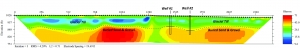
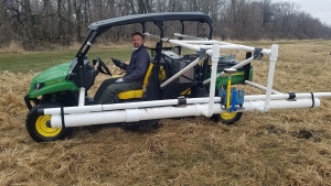
The IGS uses different types of geophysical equipment to image the subsurface (Figure 1). These new technologies allow us to use electrical or seismic sources to measure physical properties underground and formulate an interpretation of what lies below (Figure 2). Since Iowans and the world depend on resources found underground, this technology has been a gamechanger, providing practical information to many IGS projects.
Check out more about how we are using geophysics to help Iowans.